Introducing the next MCM patner school

We are more than happy to welcome the next MCM partner school! The “Jaime Cortesão Secondary School” has successfully passed the application process and is now the first MCM partner school in Portugal. The teachers of the school were inspired by the MCM MOOC last year and the trails were created by master students working […]

We are more than happy to welcome the next MCM partner school! The “Jaime Cortesão Secondary School” has successfully passed the application process and is now the first MCM partner school in Portugal.

The teachers of the school were inspired by the MCM MOOC last year and the trails were created by master students working at the school and tested with the students.

The package with the measurement tools and the official partner school badge is now on its way to the school and we are very much looking forward to receiving more applications from schools.

A short report from the school on the application process can be read further down in this article and all further information on the partner school program can be found in the article on the first MCM partner school.


Together with the supervising teacher, the interns developed the activity “MathTrails” for the students from Escola Secundária Jaime Cortesão. This activity was created using the platform MathCityMap, explored in one of the interns’ subjects from the Math Teaching Masters Degree Course from the University of Coimbra.

The created trails are called “Matematicando por Coimbra” (Code: 497843) and “ πsando as ruas de Coimbra” (Code: 697842). Our students transferred the app into their phones which gave them access to the trails and to the digital classroom that was used by the interns to control them and check their scores. The students were given a participation diploma after completing all their tasks. The winners of the activity were also rewarded with medals created by the interns.


In general, the students liked the activity, stating that the tasks had the right amount of complexity and that said tasks allowed them to recall some of the concepts learned in previous years. They also agreed that the activity was useful in order to cement their new acquired math knowledge.

The interns’ goal was to show the students that math is everywhere through a different and dynamic activity where they could explore the world that surrounds them. According to the students that goal was successfully achieved.

MathCityMap: News from Indonesia

  In 2014 MathCityMap was introduced to Indonesia with a pilot study conducted by Goethe University Frankfurt in collaboration with Universitas Negeri Semarang involving several schools in the city of Semarang. Just three years afterwards in 2017, the Mobile Math Trails Research Group was established to become a center for the study of math trails […]


In 2014 MathCityMap was introduced to Indonesia with a pilot study conducted by Goethe University Frankfurt in collaboration with Universitas Negeri Semarang involving several schools in the city of Semarang. Just three years afterwards in 2017, the Mobile Math Trails Research Group was established to become a center for the study of math trails with digital technology in Indonesia. Since then MOOCs are offered and teacher trainings are organized in collaboration with teacher organizations and the Education Offices in several cities. At some universities, MathCityMap is part of the courses taught to prospective mathematics teachers and is a topic investigated in several theses.


At the end of 2021, the Ministry of Education, Culture, Research and Technology invited the Mobile Math Trail Research Group to collaborate in organizing a teacher training on strengthening literacy and numeracy skills using MathCityMap. The speaker in the training was Professor Matthias Ludwig as the founder of MathCityMap who explained the MathCityMap concept, and the technical details of the webportal and the app in collaboration with Dr Adi Nur Cahyono, the coordinator of MathCityMap in Indonesia, and his team.


Participants in this training were 240 teachers from 34 provinces in Indonesia. Primary and secondary school teachers who were selected from 6500 applicants to the teacher training. The training was conducted in four stages and each stage was carried out in 4 days in Jakarta and Bandung. The training was realized with offline sessions which consisted of  an indoor theory lesson and an outdoor practice in the famous city parks in the two cities, namely the Bogor Botanical Gardens, Jakarta Old Town, Banteng Field, Kencana Park.


As a follow-up, the trainees returned to their respective areas and held multiplier trainings for their colleagues. They also created a mathtrail in their area with the local cultural context and implement it with students and the public. Communication with the teachers is maintained to discuss and share implementation experiences through the MathCityMap Indonesia Community forum.


MathCityMap trails and users in Indonesia have increased significantly and continue to grow as a positive impact of dissemination through MOOCs, lectures at teacher education institutes, teacher trainings and communities. In 2022, the Directorate General of Higher Education of the Ministry of Education, Culture, Research and Technology of the Republic of Indonesia will provide training on numeracy and literacy skills using MathCityMap for 22,000 university students who will undertake internships in schools throughout Indonesia.

Generic Tasks: Number

In this article on Generic Tasks, we would like to introduce you to two tasks from the “Number” category. As always, you can find the corresponding objects everywhere and the tasks can be created in no time using the task wizard. The first article on Generic Tasks, which also tells you how to get to […]

In this article on Generic Tasks, we would like to introduce you to two tasks from the “Number” category. As always, you can find the corresponding objects everywhere and the tasks can be created in no time using the task wizard. The first article on Generic Tasks, which also tells you how to get to the Task Wizard and what Generic Tasks are, can be found here.

The first object category we want to talk about here are paved areas or walls. Especially in city centers or public places you can often find areas that are paved with stones. In the picture below you can see an example of a semicircular area, which was laid out with paving stones. The task, which is provided for this in the task wizard, reads:

“With how many paving stones was the area shown laid out?”.

The values needed to create the task with the wizard are only the size of the total area and the average number of stones on a square meter. Starting from this data, the wizard fills in the complete task form and only a picture needs to be added to complete the task. Similarly, there is a task in the wizard that asks for the number of bricks that make up a wall.


Another object for which a Generic Task can be created in the Wizard is the typical advertising pillar. After manually entering the circumference and height of the area that can be placarded, the task here is:

“How many DIN A0 posters can be placed on the advertisement pillar without overlapping? DIN A0: length = 84cm; height = 119cm.”.

An interesting aspect of this problem is that it can only be solved correctly if the condition of not overlapping, which is necessary in reality, is taken into account. If you divide the surface of the cylindrical column by the surface of a poster, you get a result which is mathematically reasonable, but which turns out to be wrong in the validation on the real situation.

In the next article about Generic Taks we will have a look at the tasks in the wizard, which are available for the topic “Volume and Weight”. Until then, we hope you have fun and save time when creating MCM tasks with the task wizard!


Trail of the month: Mathtrail at the Zeppelin grandstand

The Trail of the Month January comes from the second largest city in the German state of Bavaria. Frederic Fell, a student of secondary school teaching, created the trail “Mathe-Rundweg an der Zeppelintribüne” in Nuremberg, which can be accessed in the MCM app under the code 273993. It is available in the web portal here. […]

Trail of the Month

The Trail of the Month January comes from the second largest city in the German state of Bavaria. Frederic Fell, a student of secondary school teaching, created the trail “Mathe-Rundweg an der Zeppelintribüne” in Nuremberg, which can be accessed in the MCM app under the code 273993. It is available in the web portal here.

The trail, which consists of a total of nine tasks, was created in the direct vicinity of the Nuremberg stadium, the home of 1. FC Nuremberg (Der Club), partly on the former Nazi Party Rally Grounds. In addition to the mathematics tasks, you can also explore historical topics.


Here you can find a short interview with Frederic Fell:

How did you come across the MathCityMap project? How do you use MCM and why?

I am studying to become a secondary school teacher with the subject combination mathematics / physics at the Friedrich-Alexander-Universität Erlangen-Nürnberg. I am currently writing my admission thesis (similar to a bachelor thesis, but for student teachers) in the didactics of mathematics. My supervisor Stephanie Gleich offered the topic “MathCityMap” and I was immediately interested. This admission thesis is, among other things, about extracurricular learning places, but also about modeling. The practical part of the work is my trail.


Where is your trail located? What is special about your trail?

My trail is located in Nuremberg on the former Reichsparteitagsgelände, which was used as a place for propaganda during Nazi times. Today the area is used in many different ways, as a recreation area, as a DTM race track or as a venue for the “Rock im Park” festival.
The special thing about the trail is that the relics from the Nazi era are used for better purposes, like a math trail. Of course the Reichsparteitagsgelände is a place of history, but I think it’s great how you can also learn something about math in such a place. The trail is set for ninth grade students at the Realschule. My intention is that the trail can be used as a field trip at the end of ninth grade. So we hike, do a little math and afterwards we can have a picnic at the Dutzendteich.


Briefly describe one of your tasks. How can it be solved?

I would like to describe the task “Rainbow” in more detail. 8 pillars were painted on the grandstand. You have to determine the painted area. One pillar is too big to measure. With the help of the picture you can see that 4 rectangular plates were painted on each pillar. The area of a rectangular plate can be determined. This must be taken times 4 to determine the area of a pillar and this in turn times 8 to calculate the total area. This task is varied and requires a bit of “thinking around corners”. The photographer has provided me with the rights for the pictures used in this task.


Do you have any other comments about MCM?

MCM is a really great project and I’m glad I was able to work with it as part of my graduate thesis. When I’m a trained teacher, I’ll definitely incorporate math trails like this into my teaching.

30.000 MCM-Tasks: A Happy New Year!

What better way to start the new year than with another milestone achieved for MathCityMap. We celebrate the year 2022 and the 30.000th task in the web portal! Our users were very active over the holidays and we can now be delighted with exactly 32.307 tasks in the portal. Our anniversary task, which cracked the […]

What better way to start the new year than with another milestone achieved for MathCityMap. We celebrate the year 2022 and the 30.000th task in the web portal! Our users were very active over the holidays and we can now be delighted with exactly 32.307 tasks in the portal.

Our anniversary task, which cracked the 30.000 mark, was created by Muhamad Rif’an in Jakarta and asks for the area of a rectangular platform. Click here to go to the task.

We look forward to many more MathCityMap tasks and wish you all a happy, prosperous and healthy New Year 2022!

The MCM team wishes Merry Christmas

Dear MathCityMap users, the year 2021 is now slowly coming to an end and although many things did not go as planned for many people, there were a lot of positive events and developments here at MathCityMap. With the turn of the year and the holidays in sight, now is the right time for a […]

Dear MathCityMap users,

the year 2021 is now slowly coming to an end and although many things did not go as planned for many people, there were a lot of positive events and developments here at MathCityMap. With the turn of the year and the holidays in sight, now is the right time for a short look back:

  • Over 12,000 new tasks were created in the system this year, so we now count a total of almost 30,000 tasks in the MathCityMap portal, of which about 10,500 tasks have been published. The number of tasks created has almost doubled within the last year!
  • A total of 32,000 mathtrails were downloaded in 2021. In addition, 1,300 Digital Classrooms were conducted with a total of approximately 8,800 participants and nearly 3,500 badges were awarded to MCM authors.
  • We also saw a significant increase in the number of registered users: Approximately 3,800 new MathCityMap users have registered in the system, bringing the MCM community to 10,000 members.
  • But not only the MCM community grew strongly, also our team could report some new members. We are very happy to welcome Tim Läufer, Jos Fabiunke, Rebecca Stäter and Philipp Larmann. In addition, Ivan Gurjanow and Simone Jablonski successfully completed their doctorates.
  • Our Erasmus+ project MaSCE³ (Math Trails in School, Curriculum and Educational Environments of Europe) is also being continued successfully. Therefore, we would like to thank our European partners from Portugal, France, Estonia and Spain. In particular, we would like to mention the MOOC (Massive Open Online Course) that took place in the spring of this year. A very successful online training series in which more than 100 teachers from all over the world were trained to become real MathCityMap experts.
  • In general, there were again many international events with MCM this year. From mathtrail events in Santander (Spain) to presentations at international conferences such as PME or ICTMT to teacher trainings in Portugal, Spain and Indonesia, there were again a variety of activities that brought MathCityMap closer to researchers, teachers and students.
  • Also as part of the MaSCE³ project, we were able to award the official title of “MathCityMap Partner School” for the first time. Gymnasium Trudering successfully completed the application process and can now benefit from our international network in a unique way. In addition, the students received a package with measurement tools for working on math trails in class.
  • A lot has also happened in the field of virtual teaching and distance learning. The concept of MCM@Home has been continuously developed over the past year into a stand-alone system and we are very pleased that ASYMPTOTE will be available as early as spring 2022.

Especially despite the pandemic-related restrictions this year, we are even more excited about the fantastic and exciting developments of the MCM system and last but not least the community. Without your joy in discovering and creating new tasks and mathtrails, this project would never be where it is now and therefore we would also like to take this opportunity to say thank you to all of you. Thank you for filling this digital system for school practice with life again and again and carrying it further into your communities.

We wish you and your families a Merry Christmas and a Happy New Year 2022. We are already looking forward to welcoming many new members to the MCM community and discovering new, exciting tasks around the world. Stay healthy!

Your MathCityMap Team Frankfurt

Trail of the month: Olomouc centrum (jednodušší)

The trail of the month December comes from the Czech Republic. Adéla Pantělejevová created the trail named “Olomouc centrum (jednodušší)” in the city center of Olomouc, the sixth largest city in the Czech Republic in the east of the country, while working on her thesis at Palacký University Olomouc. The trail can be accessed via […]

Trail of the Month

The trail of the month December comes from the Czech Republic. Adéla Pantělejevová created the trail named “Olomouc centrum (jednodušší)” in the city center of Olomouc, the sixth largest city in the Czech Republic in the east of the country, while working on her thesis at Palacký University Olomouc. The trail can be accessed via the MCM app using the code 795612. It is available on the web portal here.

In total there are seven tasks, designed directly on the prominent buildings of the old town. So while walking the trail, you also get to know the most beautiful sides of Olomouc. You will find a short interview with Adéla on the trail and her experiences with MathCityMap below. Enjoy reading!


How did you come across the MathCityMap project?

Once our wonderful teacher Dr. Lenka Juklová arranged a lecture by Dr. Soňa Čeretková, which was about MCM (Soňa Čeretková is working on the MCM project in Slovakia) and I became very interested in this topic. During the lecture we had a chance to do a mathtrail around the faculty and I thought it would make a great topic for my thesis, since it had not been done in the Czech Republic yet. Dr. Juklová even suggested this topic to me so I am currently working on it under the supervision of Dr. Patrik Peška at the Palacký University Olomouc.


Please describe your Mathtrail.

This particular trail is designed mainly for primary school children. It was created as part of my thesis. Most of the existing trails are designed for high schoolers, however, I wanted to create a trail for younger learners too. It is very playful, fun, and intends to show how math can be connected to other school subjects and be found anywhere, in this case in the Upper Square in Olomouc. Although my studies are focused mainly on high school mathematics, I tutor also younger children and since several of them live around the center of Olmouc I wanted them to enjoy maths through MathCityMap aswell. I also implemented the pirate theme in my lessons, which should make the whole trail more interesting for children.


How do you use MCM and why?

My goal is to show teachers how to make mathematics interesting and fun, how to use the modern technology which is available for us, and moreover to show students that mobile phones and the internet don’t have to be used only for playing games or buying clothes online, but that they can be also helpful for looking up information, educating themselves, etc.. Furthermore, I recommended these trails to my friends and classmates, who are mostly secondary school teachers and high school teachers. Some of them had already started using it in their classes or it served them as a template for creating their own trails. One of my friends is now using MCM even in his physics classes.

My friend and I are currently trying to collect some task ideas for creating a template, which could be used in a lot of different places. What we have prepared so far can be soon used in other cities. I’m very much looking forward to it.


Describe your favorite task of the trail. How can it be solved and what can students learn from it?

My favourite task of this trail is definitely “Orloj”. It is a task with several sub-tasks, in which you have to understand the meaning of each dial and determine the number and type of different ornaments.. Students get to practice hours, days, weeks, months of the year, zodiac signs, as well as orientation and location, basic arithmetic along with characters and occupations. This task is not just about mathematics, rather it also tests general knowledge of third grade students. In the task students have to choose their answers from a list of options, add numbers and names to blank spaces, etc.. So it is not like other tasks where their answers have to fall within a certain interval.

The first MCM partner school: Gymnasium Trudering

Dear users of MathCityMap, we are very happy to present you the first official MathCityMap partner school! The Gymnasium Trudering has successfully applied and is now allowed to use the title MCM partner school! The possibility to become an MCM partner school was introduced within the MaSCE³ project and the path to this title for […]

Dear users of MathCityMap,

we are very happy to present you the first official MathCityMap partner school! The Gymnasium Trudering has successfully applied and is now allowed to use the title MCM partner school!

The possibility to become an MCM partner school was introduced within the MaSCE³ project and the path to this title for interested schools is as follows:

Step 1: Visit www.mathcitymap.eu and get familiar with the MathCityMap system. If you like it, ask your colleagues to join you in your plans to become an MCM partner school!

Step 2: Create 15 tasks and 2 trails for different grades close to your school. The tasks and trails should be published in our system, peer-reviewed by your colleagues and downloaded at least 5 times by your students.

Step 3: Send your application to info@mathcitymap.eu including the trail numbers and your experiences with the trails. If you have met all the requirements, your school will be named an MCM partner school!

The students of the Gymnasium Trudering now receive measuring tools and materials from us to successfully work on Mathtrails in class. In addition, the Gymnasium will receive an official MCM partner school plaque for their main entrance and will always be informed about the latest developments of MathCityMap. As soon as the network of partner schools grows, we will provide for an international exchange between the different partner schools within the framework of the partner school project, from which all participating schools will benefit.

The whole process is completely free of charge for all schools and is co-funded by Erasmus+. You can find all further information here.

We are already looking forward to welcoming more schools as MCM partner schools! Below you will find a report about the journey of Gymnasium Trudering to become the first MCM partner school.


Our teacher was excited about the idea of using math in real and authentic situations. So were we when we heard about it. Therefore, we, the P-Seminar MathCityMap 2020/22, had set ourselves the goal of creating an interactive MathTrail directly in the natural environment. This trail should not be too difficult, but still challenging. But this was a long way.

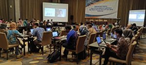
At first we studied the already created trails and tasks in Munich. Afterwards, we and one of our Q11 courses ran the trail “Discovery trip in Riemer Park” by Mrs. Haupenthal and made experiences with the digital classroom on the student side. Our P seminar course participated in the MathCityMap MOOC (Massive Open Online Course) as part of the Erasmus+ project MaSCE. It was a special experience for us to participate in a MOOC training with more than 500 international guests. We enjoyed the course very much. Through video clips we learned how to use the program to create trails and learned some background information about the project.

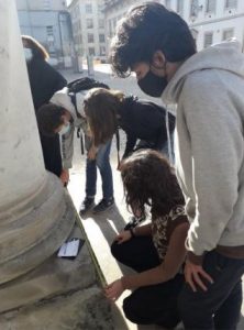
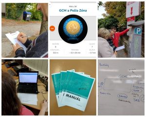
Once the use of the MathCityMap software had become clear, the course set out to create creative tasks in nature. Riemer Park was determined as the place where the tasks were to be located. Everyone then independently created two tasks in Riemer Park that could only be solved on site and associated with an activity (measuring, counting). An MCM task includes a representative photo of the object, a title, a task description, the exact position, the task type (e.g. interval, exact value, multiple choice, etc.), a sample solution, hints, indication of the class, tools (e.g. folding rule, measuring tape, measuring jar, watch, calculator, etc.) and tags. In the context of the P-Seminar MathCityMap we have made it our goal to make mathematics fun for everyone in a modern and playful way. Especially finding and creating tasks was an exciting change in the homeschooling time. It is amazing to see where you can find mathematics on the street, if you just walk around with your eyes open. So you can find tasks for almost all topics, which create an interesting connection between school and reality. Even a simple tree can become a tricky task. Lower grades in particular often find it difficult to understand what they are learning and for what purpose. This is where we wanted to start with our seminar: To get students excited about mathematics in an interesting way.

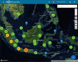
Teams were formed to develop the outdoor tasks. The tasks were posted on the web portal Mebis for everyone involved to review. There was a correction team and a team for viewing the curriculum. From the individual tasks, the route of the trail was again jointly determined, which in times of distance learning also ran via the MS Teams conference software. It was jointly considered which tasks could be grouped into so-called trails based on the subject matter and location. In total, two trails were created, each with at least six tasks in Riemer Park. After the two trails had been created, the course also decided to create a trail around the school, designed for the fifth grade of the Trudering Gymnasium.

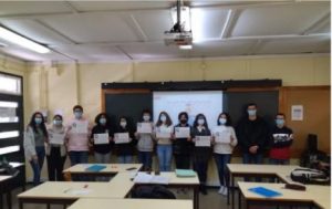
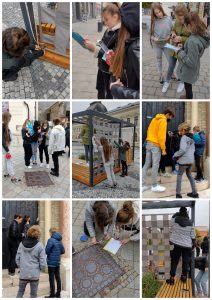
At the end of the project on 27/10/2021, a digital classroom and a walkthrough of the trail around the school were organized with the fifth grade. We evaluated the experiences made with the 5th grade. With the “Gamification” and “Narrative Pirates” settings in the MCM web portal, in our opinion, especially younger students are motivated and a competitive character is conveyed, which facilitates the achievement of learning goals and incidentally leads to the acquisition of competencies. We were particularly pleased with the positive feedback from the students after the trail was carried out with a 5th grade class. One planned trail turned into five in the end, and with Ms. Haupenthal’s trail developed during the MOOC, we created a total of 6 trails. 


Generic Tasks: Slope

In the last article on Generic Tasks, which you can read here, we already showed you how you can use Generic Tasks to save time when creating tasks in your surroundings. In this context we showed you the Generic Tasks implemented in the system for the topic Combinatorics. Another theme that the task wizard can […]

In the last article on Generic Tasks, which you can read here, we already showed you how you can use Generic Tasks to save time when creating tasks in your surroundings. In this context we showed you the Generic Tasks implemented in the system for the topic Combinatorics. Another theme that the task wizard can help with is slopes.

The objects for which Generic Tasks were created and which can also be found almost everywhere are ramps and handrails of staircases. Since, for example, ramps are not allowed to have a slope greater than six percent for use by wheelchairs, it makes sense to design an MCM task that asks exactly what the slope is.

To create the task, you only have to insert the data measured at the ramp into the task wizard and specify whether the result of the task is to be determined in percent or in degrees. The resulting task text is quite simple: “Determine the slope of the ramp in percent (degrees).


The creation of tasks with the wizard for handrails works in the same way. The sample solution and the hints are again created in a suitable way and only the task image has to be inserted.

In the next article on Generic Tasks we will deal with the creation of tasks on the topic “Number”. Until then, we wish you again a lot of fun and success in creating new tasks with MathCityMap!


MathCityMap: News from Slovakia

  Collaboration as a means of professional growth for mathematics teachers   Recently in Slovakia Mathtrails with MathCityMap were used in a professional development event for mathematics teachers, especially as an impulse for collaboration in joint development of mathematics education within the national KEGA project “Collaboration as a means for professional development of mathematics teachers”. […]


Collaboration as a means of professional growth for mathematics teachers


Recently in Slovakia Mathtrails with MathCityMap were used in a professional development event for mathematics teachers, especially as an impulse for collaboration in joint development of mathematics education within the national KEGA project “Collaboration as a means for professional development of mathematics teachers”. Janka Medová and Silvia Haringová from the Department of Mathematics at the University “Constantine the Philosopher” in Nitra and teachers from the United Catholic School in Nitra participated in the design of the mathematical trails.


During the first meeting, the teachers put themselves in the role of students. With the help of mobile devices, they tried to master the prepared mathtrail. After they had solved all the tasks, we explained to them how the MathCityMap portal works and how a mathtrail can be created. Furthermore, the teachers received a manual with detailed instructions on how to create a trail. The teachers’ task was now to come up with their own tasks and to upload them to the portal by the next meeting.


At our next meeting, the teachers discussed the tasks together and selected the best ones to create the final Mathtrail. This trail was tested out by high school students who spent two class periods walking the trail and solving tasks. Following the walk-through of the mathtrail, a joint teacher reflection took place, focusing on the importance of incorporating mathtrails into the teaching of mathematics.