Dörthe Ludwig created in Dresden the task “Majestätische Steine” (engl.: “Majestic Stones”) which we now choose as our new MathCityMap Task of the Week. In the interview, Dörthe Ludwig explaines how she uses MCM to foster her daughter’s mathematical interest.

How did you discover the MathCityMap project? How do you use MCM and why?

I am a teacher at a secondary school and attend a 4-semester extra-occupational training course at the TU Dresden. In a didactics seminar we were introduced to the MCM project in a lecture.

Since my daughter (3rd grade) was not so interested in a maths at this time, we searched together for tasks that can be found in our own environment. Now we want to create a route that she can solve together with her friends (and as many others as possible). She is already looking forward to it!

Please describe your task. How can it be solved?

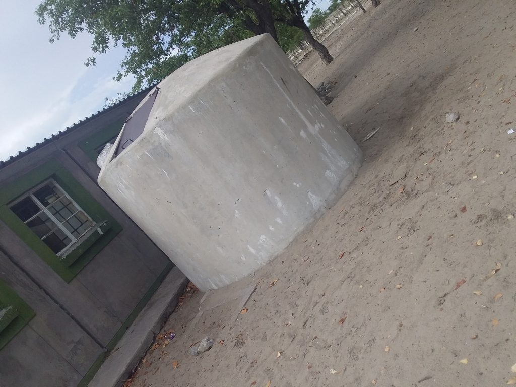
The task is to skilfully determine the number of cobblestones on a certain parking lot at the primary school. The stones are placed in such a way that it results in a simple multiplication task, but it requires multiplication beyond the small 1×1. So you can simply calculate the number, or you can break the task down into subtasks that you can calculate in your head. In this case, one must not forget to add the partial results.

What didactic goals do you aim for with the task?

To be honest, my main didactic goal was to show my daughter that mathematics can be fun even if you don’t see the solution directly, but have to make a little effort to do so. It seems to have been successful! Of course I hope that many more children will enjoy solving the problem and will be proud of themselves in the end!

Further comments on MCM?

I am enthusiastic and I will try to create many MCM tasks in Dresden. I would also like to take my students out into the fresh air and create some tasks around our school in the future.

On Monday, Iwan and Simon from the MathCityMap team Frankfurt (About Us: The MCM Team) measured, calculated and counted in the beautiful town of Bingen on the Rhine and in Groß-Gerau, Germany.

As part of the Mathtrail Seminar at the Goethe University Frankfurt, which is guided by Iwan and Simon, students created their own trail near their living place.A mutual review of the tasks is also part of the seminar: Both for experienced MCM users and “MCM rookies” a second look at the task is worthwhile, e.g. to modify the solution interval, improve the hints or clarify the task formulation.

We had a lot of fun while working on the two trails and are looking forward to their publication!

How does the creation of math trails work? How can I publish tasks or print a math trail in PDF format for my learners? We answer these and many more questions in our MCM-YouTube tutorials (click here for the playlist). Instructions on how to add subtitles in your language to the video are given in the tutorial section.

In our tutorials you will also find a MathJax guide on how to work with your tasks in LaTeX style.

Have fun watching the videos. We are looking forward to many new tasks & trails!

It’s the advertising pillar’s birthday! The first advertising pillar was installed in Berlin 165 years ago today. The advertising pillar has prevailed – and still shapes the cityscape today. Of course, the advertising pillar is also interesting from a mathematical perspective: In addition to calculating the volume or the surface area of the circular cylinder, the question of the maximum number of advertising posters can also be asked.

Advertising pillar at the Commerzbank:
How many DIN A0 posters can be attached to the advertising pillar on edge and without overlap? DIN A0: width = 84cm; height = 119cm.

To answer this question, learners have to measure the height and the circumference of the advertising pillar in order to calculate the number of posters. Learners are often surprised by the actual size of the circumference. The height of the advertising pillar is then divided by the height of the poster [number of rows of posters] and the circumference of the pillar by the width of the poster [number of posters per row]. The product of both calculations is the number of posters that can be attached. If the posters may also be hung crosswise, the calculation described must be repeated in order to determine the maximum number beyond doubt.

And now the best: For the advertising pillar task, MathCityMap provides a prepared template, a so-called Wizard Task.

Our new task of the week is in the Grand Duchy of Luxembourg! In Schifflange, Yves Kreis, senior lecturer at the University of Luxembourg, has created the task “Windows“. In the following interview he reports about the use of MathCityMap for his university teaching.

Hello Yves, you use MathCityMap for your teaching at the University of Luxembourg. How does it work exactly?

MathCityMap was presented by Gregor Milicic from the MCM team Frankfurt at the conference “Pedagogical Innovations in STEAM Education Conference” in Linz in January. My colleague Ben Haas and I found the project directly interesting. When we were forced to change our evaluation because of the COVID-19 pandemic, we decided to work out an MCM trail in groups of 2-3 students with subsequent self-evaluation and peer-review of 3 trails from other students.

You have also created some sample tasks . Please describe your task “Window”. How can it be solved? What is the aim of this task?

The task is to determine the number of square windows of a glass lift tower. On one side there are 2 rows of 12 windows each. Only 3 sides are made of glass; the fourth side is the school building. According to this there are 3 ⋅ 2 ⋅ 12 = 72 square windows. The task can be solved by all pupils from class 3 on. The aim is for the children to recognise the patterns and use multiplicative structures instead of simply counting all the windows.

Do you have any further comments on MCM?

MCM has managed to transfer an old idea (mathematical trails) into today’s digital age. A connection to AR (e.g. GeoGebra 3D Calculator) would be very useful from my experience, as many students have planned such tasks.

More information about the use of MathCityMap in Luxembourg:

Interview with Lorenzo Salucci, the 5,000 MathCityMap users & students at the University of Luxembourg

Enter the world of MathCityMap in 10 minutes? Matthias Ludwig, project manager of the MathCityMap team Frankfurt, introduced our system today at 14:40 at the CADGME online conference [Conference on Computer Algebra and Dynamic Geometry in Mathematics Education].

According to the motto “MathCityMap – a digital and pedagogical tool to do mathematics outside the classroom“, Matthias taked about mathematical modelling, the math trail idea and the MathCityMap project.

We are looking forward to lots of new MCM tasks all over the world!

Liina Shimakeleni, Mathematics and Science teacher at Omagongati Combined School in Namibia, created several theme-based math trails, e.g. about the topic volume, which are are new Trails of the Month. In this interview, Liina gives us an insight into the usage of MathCityMap in Africa. Furthermore, she talks about her experiences on the MCM system and her created trails.

Hi Liina, let’s start with our ‘classic’ first question: How did you in contact with MathCityMap?

I am a Mathematics and Science teacher at Omagongati Combined, I have been teaching at this school for eight years. I registered with the Rhodes University (South Africa), doing Masters in Mathematics Education. We attend contact classes in NIED Okahandja, Namibia. In 2019 Matthias Ludwig, a senior lecturer from Goethe University, paid us a guest lecture and introduced the MCM project. I embraced the whole MCM idea and thought it was in line with my research area, which is to discover how mathematics learned in the classroom is linked to real life through outdoor activities– as advocated by the MCM project.

What are your personal experiences with MathCityMap?

My very first encounter was not an easy one. After solving tasks that were set by Matthias it was our turn to set our tasks in the NIED Okahandja campus. I did not find a task that day because I did not want any mathematics task, but I wanted a task that is related to what I ask from/discuss with my learners in the mathematics class.

Your trails were downloaded very often in the last month. How do you use MathCityMap? Please describe your theme-based math trails.

I use MCM in my research to find out how Grade 9 learners use smartphones and visualization to learn measurement.

The uniqueness in my tasks is that each trail consists of tasks that are resourced from Perimeter, Area and Volume topics in school mathematics curriculum. For example, in the task ‘Volume of a tank’ learners are asked to calculate the volume of an old tank in the school ground, where they could not measure that radius of that tank directly. This task requires learners to make this complex task into simpler steps by finding the radius from circumference [C=2·π·r] and use value r to find the volume [V= π·r2·h].

Let’s have a look on Liinas theme-based math trails:

Name

Topic

Code

Number of Downloads

Omagongati Perimeter Trail

Perimeter

132336

43

Omagongati Area Trail

Area

152516

18

Omagongati Volume Trail

Volume

012527

71

Please describe the school yard of Omagongati Combined. Why did you create this route?

Omagongati is a rural school in the northern part of Namibia. The school may not have a lot of buildings and state of the art structures, but the little we have is surely worthwhile to discover some mathematics. Running an MCM trail allows learners to leave the boundaries of the classroom and engage with hands-on measurement activities. The smartphone can be used to create learning tasks that can be shared, solved in groups, published and used to generate discussions among users, learners in my case.

Do you have any other commentary on MathCityMap?

Learning for understanding calls for activeness, human interaction with learning environment. The use of smartphones that was previously discouraged can be useful as a learning tool to enhance learning experience in young people especially that we live in an era that involve constant engagement with mobile technology. I am fortunate to learn about MathCityMap.

Last October, the MathCityMap team from Frankfurt visited the city of Constance [dt. Konstanz]. At Lake Constance our team is laying out a total of 14 new trails, which will be released today!

With the support of the Stiftung Rechnen and the city of Constance we have created many interesting math trails for classes and families in the beautiful city of Konstanz. The Mathe.Entdecker trails [engl. Discovering.Maths trails] lead around the harbour, along the Rhine promenade, through the city centre or through the Paradise Quarter. In addition, a “border trail” was created on the German-Swiss border. However, the grand opening with school classes trying out the mathtrails had to be cancelled due to the Corona pandemic. With the following links you can access the articles of Stiftung Rechnen and Marketing und Tourismus Konstanz GmbH about our new math trails.

In the following we list all our created trails in Konstanz. We wish you a lot of fun and success!

Titel incl. Link

Code

Duration| Distance

Konstanz Innenstadttrail
[Around the City of Constance]

672257

2h 10 min | 1.400 m

Konstanz Hafentrail
[Around the Harbour of Constance]

022256

2h 20 min | 1.100 m

Konstanz Grenztrail
[Along the Swiss-German Border]

492255

2h 10 min | 1.700 m

Ein Nachmittag in Konstanz
[An Afternoon in Constance]

352258

4h 20 min | 3.400 m

Mathe für Entdecker – Klasse 3/4
[Discovering Maths – Grade 3/4]

472261

1h 30 min | 1.000 m

Konstanz Familie – Klasse 3/4
[Families in Constance  – Grade 3/4]

452260

2h 50 min | 3.400 m

Mathe am Rhein – Klasse 5/6
[Maths along the Rhine – Grade 3/4]

472262

2h 20 min | 2.200 m

Quer durch Konstanz – Klasse 5/6
[Across Constance – Grade 5/6]

092264

2h 10 min | 1.500 m

Konstanz Familie – Klasse 5/6
[Families in Constance  – Grade 5/6]

562263

3h 00 min | 3.300 m

Mathe im Paradies – Klasse 7/8
[Maths in Paradise – Grade 7/8]

292265

1h 40 min | 1.300 m

Quer durch Konstanz – Klasse 7/8
[Across Constance – Grade 7/8]

072277

2h 10 min | 1.500 m

Mathe am Rhein – Klasse 7/8
[Maths along the Rhine – Grade 7/8]

192276

1h 50 min | 700 m

Mathe am Rhein – Klasse 9/10
[Maths along the Rhine – Grade 9/10]

132259

2h 10 min | 1.400 m

Mathe im Paradies – Klasse 9/10
[Maths in Paradise – Grade 9/10]

132267

2h 40 min | 1.900 m

Our community is growing rapidly: One week ago, Lorenzo Salucci, a student teacher from Luxembourg, registered as 5,000th user in our portal. All in all (and despite of Corona), we have already welcomed more than 1,000 new users to MCM this year. Our “anniversary user” Lorenzo Salucci gave us an interview about the MathCityMap system which is presented in the following.

Mr. Salucci, you are a student at a Luxembourg university. How did you get in contact with the MathCityMap project? How is it used in the university?

Exactly, I am a student at the Université du Luxembourg and am studying to become a teacher. I came across the MathCityMap project in our mathematics course “Didactics of Mathematics”. In our course, the project is used as a substitute for exams because of the Covid-19 pandemic. We have to create a math trail in small groups near primary schools in Luxembourg. These are then evaluated by our teachers and fellow students.

Have you already had your first practical experience with MCM? What do you expect or promise from the use of MCM in everyday school life?

Personally, I haven’t had the opportunity to do a trail yet, but I plan to try out a math trail in the next few weeks. I believe that the use of an MCM makes it possible to give the students an understanding of mathematics in the outside world. Many people think that mathematics is only taught very theoretically at school. However, the MCM gives you the opportunity to bring applied and realistic tasks as well as other mathematical riddles into real everyday situations.

You have already created your own tasks. What is it about exactly?

Together with two colleagues we have already created our own trail “Mathematik Trail nahe der Scheierhaff-Schule” (engl.: “Math Trail near Scheierhaff School”; Code: 452734). This trail is located on the property of the primary school “Scheierhaff” in Soleuvre, Luxembourg. One task from this trail is located in the playground of the kindergarten, the object of the task is a raised bed. The mathematical topic of this task is the volume. The students have to calculate the volume of this raised bed. One of our teacher’s demands is that we give the pupils two tips on how to solve the task, so we decided to give the children the formula for the volume (volume = length x width x height) and we gave them the hint that 1 meter corresponds to 100 centimeters.

More than 14,000 tasks (red line) have been created by now more than 5,000 users (green line) in the past four years. That’s great! Thanks to all active users of our system!

We are very pleased to announce the publication of our ROSETA proceedings (Research on Outdoor STEM Education in the digiTal Age) as online open access: doi.org/10.37626/GA978

The conference was planned within the framework of our Erasmus+ project MoMaTrE. All MathCityMap related papers in our ROSETA proceedings can be separately downloaded via the added doi-links.


MathCityMap related papers in the ROSETA proceedings: