Task of the Week: An off-limits flowerbed

Emanuele Amico, teacher student of the University of Catania in Italy, created our new Task of the Week. In the interview, he describes the task “Una aiuola off-limits“ [“An off-limits flowerbed”] and gives us an insight how the University of Catania [partner in the MaSCE³ project] uses MathCityMap in teacher education courses.   How did […]

Emanuele Amico, teacher student of the University of Catania in Italy, created our new Task of the Week. In the interview, he describes the task “Una aiuola off-limits“ [“An off-limits flowerbed”] and gives us an insight how the University of Catania [partner in the MaSCE³ project] uses MathCityMap in teacher education courses.


How did you get to know the MathCityMap system? How do you use MathCityMap?

I have started using MathCityMap only a few months ago. I am attending a Master’s Degree course in Mathematics at the University of Catania. During the lessons of the “Mathematics Education” course the teacher presented the MathCityMap project, highlighting the theoretical framework and the methodological aspects on which it is based, the needs to which it responds, the ways in which the objectives of the project are pursued. I had the opportunity to experience MathCityMap from both sides: as a student, through participation in a math trail prepared by the teacher and proposed to the class group, but also as a creator of my own task that met the requirements for publication [see “Criteria for a good task” on our tutorial page]. In this context, taking inspiration from a traffic island in the immediate vicinity of the Department of Mathematics and Computer Science, the idea of my first (and so far only) task “An off-limits flowerbed” was born.


Describe your task. Where is it located? What is the mathematical question? How can you solve it?

The task requests the calculation of the area of a surface identified by the marker strips delimiting a traffic island. It is clear that the area can be identified as a triangle, but it is also clear that it is not possible to measure directly any of the three heights of the triangle, because of the presence of plants and shrubs in the flowerbed inside the traffic island, which make it inaccessible. Therefore, to solve the task, it is possible to use trigonometry, and in particular to generalize of the formula for calculating the area of a right-angled triangle. By measuring the lengths of two sides of the triangle with a ruler or string, and measuring the angle between them with a goniometer, the student will be able to calculate the area required. An alternative way of solving the problem can be based on the use of the formula: A = ½*a*c*sin


What are the learning objectives of this task? What could students learn while working on this task?

From the didactic point of view, the task requires for a reflection about the best and most practicable way of solution (which sometimes does not coincide with the initial idea). The task is an invitation for the student to critically compare different solving strategies, to reflect on the necessity of knowing several methods and formulas that allow to reach the same objective, since often each of them is based on different assumptions and needs, in our case on the impossibility of making an internal measurement of the geometric figure.


Do you have any other comments on MathCityMap?

I believe that MathCityMap truly offers an authentic context for learning mathematics and I am sure I will continue to use it in the near future.  

19.000 tasks on the MathCityMap Web Portal!

Ceren Kaya has created the 19,000 task on the MathCityMap Web Portal! As part of the seminar “New Media in Mathematics Education” at Frankfurt Goethe University, the use of MathCityMap in the classroom is of course also discussed. For this purpose, the student teachers get to know the MathCityMap system from the learner’s point of […]

Ceren Kaya has created the 19,000 task on the MathCityMap Web Portal! As part of the seminar “New Media in Mathematics Education” at Frankfurt Goethe University, the use of MathCityMap in the classroom is of course also discussed.

For this purpose, the student teachers get to know the MathCityMap system from the learner’s point of view and work on a math trail of their choice. In addition, the use of our tool Digital Classroom is reflected upon (teachers’ perspective).

From the author’s perspective, the students create their own assignments. For this purpose, a picture of the monument of the Hassia spring in Bad Vilbel as well as the corresponding dimensions of the base were given. The student teacher Ceren Kaya then created the task “Mathematics with a magic hand”, in which the volume of the base is to be calculated.

We look forward to many more tasks on MathCityMap!

Task of the Week: The Ring

Dominik Enders, a student of the German grammer school (Gymnasium) in Bad Neustadt, created our new Task of the Week (the task “Ring”). In the interview, he explains why the students at his school create their own MCM tasks.   How do you use MCM and why? I participate in a project, led by teacher […]

Dominik Enders, a student of the German grammer school (Gymnasium) in Bad Neustadt, created our new Task of the Week (the task “Ring”). In the interview, he explains why the students at his school create their own MCM tasks.


How do you use MCM and why?

I participate in a project, led by teacher Ms Gleichmann, in which we create math trails for pupils from younger classes, which you can tackle in your free time or on hiking days.

Describe your task. How can it be solved?

My problem is about a ring-shaped piece of sports equipment on a playground, of which you are supposed to find the area of the upper side. Assume that the edges of the ring are smooth, i.e. without indentations.

First you have to calculate the area of the circle up to the outer edge of the ring (tape measure/inch stick and pocket calculator are required) by determining the radius and then
calculate the area of the circle. Using the same procedure, calculate the smaller area of the circle enclosed by the inner edge of the ring. Then you only have to subtract the smaller area from the larger one to get the area of the top of the ring.

What didactic goals do you pursue with the task?

The task refers to the teaching content of the 8th grade and represents an application of the pupils’ knowledge on the topic of the area of a circle. The circle-ring is more demanding, but this can be mastered by using the area formula for two circles. The reference of mathematics in the 8th grade to a piece of sports equipment on a playground, which the pupils know from their everyday experience, should be motivating. By measuring lengths (radii), the topic of sizes from Year 5 is also addressed, as well as the importance of measuring accuracy.

Note: The task “Shoe size of the statue” was also created by a pupil of the Rhön-Gymnasium. It was the 15,000th task at MCM – great!

Online Course: Task Design for Math Trails

The Erasmus+ funded MaSCE³ project proudly presents its Massive Open Online Course (MOOC): Task Design for Math Trails. Are you interested in doing outdoor mathematics with your students? Do you search for interesting and motivating ways of teaching? Do you want to get in contact with teachers all over Europe?   With our MOOC, we […]

The Erasmus+ funded MaSCE³ project proudly presents its Massive Open Online Course (MOOC): Task Design for Math Trails.

Are you interested in doing outdoor mathematics with your students? Do you search for interesting and motivating ways of teaching? Do you want to get in contact with teachers all over Europe?


With our MOOC, we intend to

  • introduce the system MathCityMap® for teaching mathematics outdoors with digital tools,
  • show you how you create your own tasks and trails in the system and honour the best tasks with badges,
  • share experiences on an international level.

We kindly invite all mathematics teachers to take part in this MOOC. It is part of the Erasmus+ project MaSCE³, co-funded by the European Union and therefore free of charge.


Basic information:

  • Start: 8th March 2021
  • Duration: 12 weeks
  • Language: English
  • Enrollment: http://dimamooc.unict.it/ (starts on 15th February 2021)
  • Certification: Certificate after completing the course (30 hours) + badges on DiMa Platform that you can put in your own wallet on http://badgr.com + an analog certification from MathCityMap

For more information please visit the project website www.masce.eu/mooc and watch our video https://youtu.be/Kc7CbZleq4A


We hope you are interested to join our MOOC and learn more about tasks, outdoor math and digital tools. It will be our pleasure to welcome you online on 8th March!

In case of questions, do not hesitate to contact your national organizing person:

Estonia: Andrus Rinde andrus.rinde@tlu.ee
France: Christian Mercat Christian.mercat@univ-lyon1.fr
Germany: Simone Jablonski jablonski@math.uni-frankfurt.de
Italy: Eugenia Taranto Eugenia.taranto@unict.it
Portugal: Elisabete Cunha elisabetecunha@ese.ipvc.pt
Spain: Claudia Lázaro lazaroclaudia@gmail.com

Trail of the Month: Monuments of Lille

Severin Philippe, a math teacher of Lille, is the author of our current Trail of the Month. Last year, he created the math trail “Balade autour des monuments de Lille“ (Code: 361576) in order to organize a mathematical city walk through Lille for European exchance students. How do you use MathCityMap? In January 2020, I […]

Trail of the Month

Severin Philippe, a math teacher of Lille, is the author of our current Trail of the Month. Last year, he created the math trail Balade autour des monuments de Lille (Code: 361576) in order to organize a mathematical city walk through Lille for European exchance students.

How do you use MathCityMap?

In January 2020, I organized the trail for my students and their German, Romanian and Italian penfriends during the Erasmus+ exchange week in France. I use MathCityMap every year with my students and one of my colleagues who teaches French – students have to look for information about Lille monuments before the trail.

Please describe your trail. Where is it placed?

I used to do this trail before and I discovered the MathCityMap application only afterwards. This city centre trail of Lille is the first one I have created so far.

Why did you create this route? Which didactic aims do you want to stimulate through this trail?

I created this trail because it’s important to me to show my students that mathematics is everywhere around us. The students tend to be more active and motivated outside the classroom.

Task of the Week: Chinese Multiplication

Our new assignment of the week shows how MathCityMap can support Distance Learning. In this interview, our student assistant Franzi Weymar explains how she uses MathCityMap in the context of the gifted education program “Junge Mathe-Adler Frankfurt”. How do you use MCM with the math eagles? The Junge Mathe-Adler Frankfurt are a project for mathematically […]

Our new assignment of the week shows how MathCityMap can support Distance Learning. In this interview, our student assistant Franzi Weymar explains how she uses MathCityMap in the context of the gifted education program “Junge Mathe-Adler Frankfurt”.


How do you use MCM with the math eagles?

The Junge Mathe-Adler Frankfurt are a project for mathematically particularly interested as well as gifted students. Normally, the students are offered the opportunity to deal with mathematical problems and topics outside of the school setting every two weeks at the Institute for Didactics of Mathematics and Computer Science at Goethe University Frankfurt. However, the pandemic situation this year required special circumstances, as the usual face-to-face sessions could not take place. Using the MCM platform, it was possible to design trails with thematically coordinated tasks for both home and outdoor use. This made it possible to offer the students a versatile and varied range of activities and to successfully implement extracurricular, mathematical support during this special time.

Describe your task. How can it be solved?

In general, the trail “Rechentricks für die Mathe-Adler” [engl.: “Calculation Tricks for the Mathe-Adler”], from which the task “Chinesische Rechenmethode_Aufgabe 1” [engl.: “Chinese Multiplication_Task 1”] is taken, deals with calculation tricks for fast multiplication.

The Chinese multiplication method is about multiplying two two-digit numbers together in a simple and quick way by visualizing them through a figure. The tens and ones digits are first mapped into corresponding numbers of slanted lines. By counting the intersections of the lines from left to right, the place values of the result can be read from the hundreds place to the ones place. In the task selected here, the students should now try to read off the result of the multiplication task shown (22-22) by counting the intersections and assigning them to the corresponding place values. The hints and the sample solution serve as help and explanation for the students to be able to solve the task or to understand it well. Previously, the Chinese multiplication was explained by means of an example task.

What can students learn here?

By working through the trail on the various calculation tricks, students can learn simple and quick procedures for solving multiplication tasks, which can also be useful to them in their everyday school life. In addition, the thematization of the cultural reference of the different arithmetic tricks promotes the examination of mathematical topics from other countries, because mathematics can be found everywhere.

To what extent can the MCM@home concept help organize homeschooling in mathematics?

Within the MCM@home concept, the Mathe-Adler team is offered the possibility of setting up a digital classroom in addition to the interactive learning setting for students. This means that at the same time as the Young Mathe-Adler session would normally take place in presence, a learning space, the so-called Digital Classroom, is activated for a selected time slot with the respective tasks. This ensures that we as the Mathe-Adler team can see the learning progress of the participating students in real time, can respond to questions and comments from the students during the session via the chat portal, and thus, despite the distance learning, there is a direct exchange with them. In addition, students always receive direct feedback on their learning success through hints and the sample solution provided. Homeschooling in mathematics can thus be organized in an appealing, versatile and simple way using the MCM@home concept.

A look back at the MCM@home Teacher Training!

Yesterday, 12 German mathematics teachers participated in our MCM@home training, which was delivered online by Matthias, Gregor and Simon. In three practical phases, the participants learned about the MCM@home idea from the perspective of the learners, the teachers and the MCM authors: Learners’ Perspective: Teachers worked on our “MCM@home professional development” trail, which can be […]

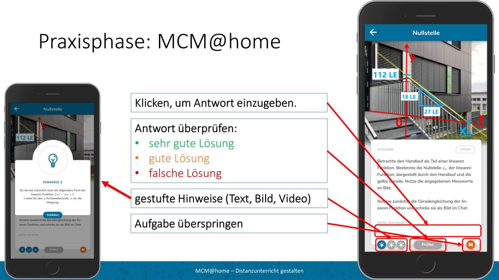
Yesterday, 12 German mathematics teachers participated in our MCM@home training, which was delivered online by Matthias, Gregor and Simon. In three practical phases, the participants learned about the MCM@home idea from the perspective of the learners, the teachers and the MCM authors:

  • Learners’ Perspective: Teachers worked on our “MCM@home professional development” trail, which can be accessed and worked on via the MCM app using the code 783277.
  • Teachers’ perspective: we introduced teachers to the Digital Classroom as an analysis and diagnostic tool for evaluating digital learning trails.
  • Authors’ perspective: In addition to creating three tasks, teachers also each created their own trail and shared it with a workgroup.

Conclusion: In an “instructive, straight and well organized and structured program” (comment of a participant) we presented MCM@home as one promising opportunity for Distance Learning and are looking forward to many new MCM@home tasks!

A brief look at the MCM statistics

Dear users, MathCityMap as a participatory project thrives on you using the existing tasks & mathtrails and creating your own tasks & trails. Today we would like to present you some numbers from the MathCityMap statistics: A total of 18,600 tasks have been published on the MathCityMap web portal since mid-2016 – of which nearly […]

General

Dear users,

MathCityMap as a participatory project thrives on you using the existing tasks & mathtrails and creating your own tasks & trails. Today we would like to present you some numbers from the MathCityMap statistics:

  • A total of 18,600 tasks have been published on the MathCityMap web portal since mid-2016 – of which nearly 6,000 were published in 2020. Of these, approximately 7,000 tasks were published.
  • 2100 new users have registered with MathCityMap in 2020. In total, the MCM community now counts 6,400 members.
  • The most downloaded mathtrails war 2020 the trail “Forum 2020” by Christian Mercat in Marseille and the trail “[EN] Berlin Gendarmenmarkt” by Simone Jablonski. The MCM@home trail “Campo de fútbol del Racing de Santander” by Claudia Lazaro won the third place.
  • In total, our more than 60 MCM@home trails for distance learning in the Corona pandemic have been downloaded more than 1500 times. Fantastic!

We are already looking forward to welcoming many new members to the MCM community in 2021 and discovering new, exciting tasks all over the world.

Your MathCityMap Team Frankfurt

Task of the Week: Climbing Frame

Patrick Rommelmann has created our new task of the week on the schoolyard of the Regenbogen-Gesamtschule Spenge – the task “Climbing Frame”. The task is located in the theme-based math trail “Route RGeS”, which focuses on the repetition of cylinders. Mr. Rommelmann has already tested the trail with a 10th grade class.   How did […]

Task of the Week

Patrick Rommelmann has created our new task of the week on the schoolyard of the Regenbogen-Gesamtschule Spenge – the task “Climbing Frame”. The task is located in the theme-based math trail “Route RGeS”, which focuses on the repetition of cylinders. Mr. Rommelmann has already tested the trail with a 10th grade class.


How did you come across the MathCityMap project? How do you use
MCM and why?

I became aware of the MathCtityMap project during my mathematics didactics training at Bielefeld University. At the university, a math trail has already been created, which I worked on in a seminar.
In the seminar for writing my master thesis the MathCityMap project came up again and I decided to create a math trail and test it with a school class. After positive feedback, I have now published the tasks so that other teachers can work on the math trail with their classes.

Describe your task. How can it be solved?

In this task, we are to determine the length of the lowest blue rope. The beauty of this task is that there are different possible solutions. The rope forms the shape of a circle. Therefore, the radius of the circle can be measured and then the circumference of the circle can be calculated.
A more intuitive solution option is to measure the entire circumference of the circle. However, this can take quite a long time if the many, individual sections have to be measured one after the other. A clever variant can be chosen here if only one section is measured and this is multiplied by the number of all sections.

What didactic goals are you pursuing with the task?

In particular, the variety of solutions should create an openness of the task. Open tasks are particularly well suited for heterogeneous learning groups, which are also increasingly found at this comprehensive school. In addition, the MathCityMap task had the typical didactic aspect of modeling on real objects.

What other tasks could be investigated on this exciting object be investigated?

Starting with questions about the circle, further questions about the shape of the climbing frame as a cone could arise at the climbing frame. In addition, the pole to which the climbing frame is attached could also be investigated. The pole has the shape of a cylinder, so for example with given density and weight, the length of the pole could be determined. The result could be used to check how secure the climbing scaffold is in the ground. Of course, the necessary information would have to be obtained beforehand.

Further comments on MCM?

As you can see from this nice example, mathematical questions can be found on many objects in our world. With MathCityMap, an app has been created that can successfully establish the application connection of mathematics to the objects.

The MCM Team wishes Merry Christmas

Dear users, Another year is drawing to a close (this time probably a very turbulent one for all of us). Christmas is just around the corner. Time for us to take a brief look back at the past year: This year, almost 5,500 new tasks were created in the system, so that we now count […]

Dear users,

Another year is drawing to a close (this time probably a very turbulent one for all of us). Christmas is just around the corner. Time for us to take a brief look back at the past year:

  • This year, almost 5,500 new tasks were created in the system, so that we now count a total of almost 17,600 tasks in the MathCityMap portal, of which about 7,000 tasks were published.
    We also saw a sharp increase in registered users: Approximately 2000 new MathCityMap users registered in the system. In total, the MCM community now counts 6,200 members.
  • Our Erasmus+ project MoMaTrE (Mobile Math Trails in Europe) was successfully completed. We would like to thank our European partners from Lyon (France), Porto & Lisbon (Portugal), Santander (Spain) and Nitra (Slovakia) as well as our app developer team from autentek in Berlin for the great collaboration over the past three years. At the end of the project, the ROSETA proceedings all about extracurricular learning with digital media in science and technology subjects was published – of course, the focus here was also on our MCM system.
  • In May we were able to present our new MathCityMap web portal: In the new design, creating tasks & trails is even more fun – especially since there are now also awards for working with MathCityMap: For creating tasks & trails, running digital classrooms, downloads of your own trails or your contact to other MCM users, you can collect up to six badges each.
  • To make running MCM trails even more fun, we’ve also given our app a new design. In addition to the visual redesign, the app now offers the option to create tasks and trails directly on your phone.
  • To support virtual teaching and distance learning, we developed the MCM@home concept: due to the pandemic, the idea here was to solve tasks from home rather than on site. In total, more than 60 MCM@home trails were created worldwide, which were downloaded more than 1500 times. Fantastic!

Not only because of the Corona pandemic, but also caused by the presented further developments of our MCM system, the past year was exciting for us. However, the great development of the user numbers and tasks would not have been possible without your help and use of the platform. And so, despite all the changes, MathCityMap remains what it is: a digital system for school practice.

We wish you and your families a Merry Christmas and a Happy New Year 2021. We are already looking forward to welcoming many new members to the MCM community and discovering new, exciting tasks all over the world. Stay healthy!

Your MathCityMap Team Frankfurt