The Trail of the Month of June comes from the small medieval town of Bruneck in the region of South Tyrol in northern Italy. Here, Melanie Forer and her third-grade students created the trail “Bruneck einmal anders” (Brunico a little different), which can be accessed with the MCM app under the code 353905 and is available on the MathCityMap web portal here.

The trail consists of a total of six tasks that mostly revolve around the topics of areas and volume calculation of basic and composite objects and areas. In addition, of course, you have the pleasure of getting to know Bruneck from a completely different perspective, while at the same time visiting sights such as the castle of Bruneck.


An interview about the creation of the trail and her experiences with MathCityMap is given by Melanie Forer below:


How did you come across the MathCityMap project?

I got to know MathCityMap in the context of the further training ” Mathematical Trails” of the Pedagogical Department in South Tyrol. Using the example of the project “matematica in città” in Bolzano, we interested teachers were invited to observe the environment with a mathematical eye and then familiarize ourselves with the app MathCityMap. The possibility to formulate and solve mathematical questions at extracurricular learning sites appealed to me very much, so I also brought this idea to my class, where it immediately received a lot of approval.


Where is your trail located? What is special about your trail?

The small medieval town of Bruneck in South Tyrol, Italy impresses with its castle and the famous town alley. In 1741, the Ursuline Order settled in Brunico and in the following years the Ursuline Sisters built a church, convent, boarding school and school. Pupils of this equated secondary school have created the mathtrail “Bruneck einmal anders”, which is described as follows:

Starting from the school entrance at the Ursuline Church, the route goes through the eponymous Ursuline Gate via the historic Stadtgasse up to the Upper Town. From there it continues up to Bruneck Castle and across the suspension bridge to Hermann-Staudacher-Platz. Afterwards the trail goes back to the Schlossberg, down to the Rainkirche and over the trench to the Hintergasse. With the trail it is possible to get a new perspective on the sights of Bruneck by putting otherwise inconspicuous, everyday, geometric figures and bodies in the center of attention.


How do you use MCM and why?

I use MathCityMap to offer very practical, modern mathematics lessons that are close to the students’ lives. Through new digital media, such as MathCityMap, the student world can become a place of learning and a new approach to mathematics can be created. The mathematical perspective no longer remains only in the classroom, but is increasingly applied in the playground, on the way to school or in leisure time.

This school year, I will again be working with a small group of students to collect new tasks and take on the mathematical challenge.


Describe your favorite task on the trail. How can it be solved?

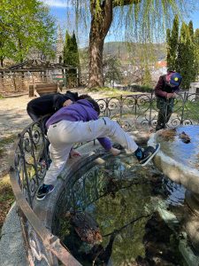
My favorite task is the “bridge at the castle”. With a bit of a thrill, but of course with maximum safety, you can enjoy a wonderful view of Bruneck Castle. The task is to measure the area of the fence and calculate the cost of redesigning it. The special thing here is the varied approach to determining the length, with measuring and counting with meter tape folding rule or other aids such as thread, step length, etc.. To be able to solve the task, basic knowledge of calculating the area of rectangles and an understanding of direct proportionality is needed.


Also from Slovakia the first schools are joining the partner school program of MathCityMap. We are very happy to welcome “ZŠ s MŠ Lipovce” and “Základná škola Revúca” as the new and fifth / sixth partner school, which successfully passed the application process.

The process at ZŠ s MŠ Lipovce was initiated by Sylvia Smolková, a dedicated mathematics teacher at the school, which has a kindergarten, primary and secondary school.
Four trails were created for grades 5 (075303), 7 (025383), 8 (675400) and 9 (565437), which lead the school’s students across Lipovce and let them discover the community in a new way. Trying out the trails with the classes was a lot of fun for all involved and especially the experience of doing mathematics outside was a great motivational factor, as Sylvia Smolková told us.

At Základná škola in Revúca, the application was submitted by Michaela Štefko, who described her experience with MCM as follows:

“I work at the primary school in Hviezdoslavova street in Revúca. Our students are always open-minded to new and interesting forms of learning. As soon as we came across the application and the portal Mathcitymap, we immediately decided to use it in our lessons. So far, we have created two trails in the area of our school for the 5th and 6th grade. We are currently working on another one for the 7th grade. My colleague and I have recently started to design a mathematical walk in our town. We would like to present the monuments and significant places in our district town. Our students have already passed both routes, they were all excited, they formed groups very quickly and worked nicely on every single task. They even suggested that they take part in creating other tasks. We want to improve students´ reading comprehension, teamwork and also communication skills. Additionally, we see a great benefit in the fact that students, whose favourite school subject is not mathematics, took part in solving mathematical problems.”

The packages with the measuring tools and the official partner school plaque are already on their way to the schools and, as always, we are very much looking forward to receiving further applications from all over the world.

All further information about the partner school program and the prerequisites for the application can be found in the article about the first MCM partner school as well as on the homepage of our project MaSCE³.


Through the Trail of the Month of May, we get to know a European capital from a slightly different angle. We’re talking about Finland’s largest city, Helsinki, where Nina Salminen, a local mathematics, chemistry and physics teacher, created the Helsinki Tour trail, which is available in the MCM app by using the code 129638 and on the MathCityMap web portal here.

On this extensive mathematical walking trail we get to know the city and its sights in connection with six mathematical tasks based on intermediate level topics. Starting at the Sibelius Monument, the trail covers a total distance of 2.9 km, passing the Olympic Stadium, the Parliament Building and the famous Temppeliaukio Church, which was carved directly into a rock.

In a short interview Nina Salminen tells us how she got to know MathCityMap and gives us some background information about her trail:


How did you come across the MathCityMap project?

My Italian colleague Giovanna Zito from Brindisi asked me to join an Erasmus+ project, where a MathCityMap trail is being planned with students in each of the five countries participating in the project. I found out about the MathCityMap project and made one trail with my students near our school, Munkkiniemi School. This spring we went further and planned two trails in the center of Helsinki.


Please describe your Mathtrail.

Along the trail you will see points of interest in Helsinki and at the same time solve short math problems. For each task, you will get to know one of Helsinki’s attractions. Thus, the route also serves as a tourist tour in our capital. Math problems are suitable not only for students but also for anyone who wants to recall the basics of mathematics or enjoy problem solving.


How do you use MCM and why?

MCM trail brings good variation for math lessons. A trip outside breaks up the monotony of the school day. Showing math in different contexts is also a good way to reach students who, for one reason or another, don’t like math and don’t think they’re good at it.

We can also get around the trails on theme days or when there are foreign guests at our school. The trail makes it easy to introduce our hometown. The Finnish mobility of the Erasmus+ project will take place in May and all 50 students from five different countries will take the MCM trail.


Describe your favorite task of the trail. How can it be solved and what can students learn from it?

My students have come up with ideas for the tasks and were so excited about planning them that I consider everyone a favorite. The tasks differ from each other and many of them require knowledge of geometry. In addition to connect math with real life, students get to know their hometown. They also learn to work together as a group when solving tasks and navigating from one task to another.

The Trail of the Month for April was created at a picturesque location on Lake Constance, on the island of the city of Lindau in Bavaria. Together with his P-Seminar, a special type of course in the Bavarian gymnasiale Oberstufe, teacher Jan Neuendorf created the “Lindau Island Mathtrail” (Lindauer Insel Mathtrail), which is available in the MCM app under the code 376526 and in the MathCityMap web portal here.

Along the harbor and through lindau’s old town, the trail winds its way across the entire island and integrates various sights of the city, making it very interesting not only mathematically, but also architecturally and historically. The trail contains a total of ten tasks that focus in particular on the content of the eighth and ninth grades.


An interview about the background of the trail is given by Jan Neuendorf in the following interview:


How did you come across the MathCityMap project?

I first heard about the project from colleagues who had spoken about it in various training courses. Afterwards, I found out more about the MathCityMap project on the Internet. This gave me the idea to offer a P-seminar in mathematics, which had the goal to develop a Math-Trail on the island of Lindau and to make it accessible to interested people via the MathCityMap-App. The P-Seminar is a special feature of the gymnasiale Oberstufe in Bavaria. It supports students in their study and career orientation and focuses on the planning and implementation of a subject-related project.


Where is your trail located? What is special about your trail?

The trail is located on the island of Lindau in Lake Constance. With its historic old town, narrow streets, medieval buildings and picturesque harbor with lighthouse, lion and mountain view, the island provides a unique backdrop for the elaborate math trail. Therefore, it was also an exciting challenge to discover and develop suitable mathematical tasks on objects on the island. Thus, the trail combines sightseeing with math activities, which is an exciting combination.


How do you use MCM and why?

So far, MCM has served as a guiding idea for the P-Seminar in mathematics. The goal of the participating students was to plan and implement a math trail on the island of Lindau. In the future, the trail will be used in grades 9 and 10 as a subject outside the classroom or as part of our project week. It is certainly also desirable that other schools in the Lindau area will use the trail for classroom excursions and class action days.


Describe your favorite task on the trail. How can it be solved?

My favorite task of the trail is the task to the Mangturm (Mangtower) at the Lindau harbor. On the one hand, the task is to be solved directly at the harbor in the heart of Lindau, which gives the task an exposed place within the trail. On the other hand, it is a suitable task from the field of geometry, in which mathematics is applied in practice and in which geometry as the science of measurement can be understood in its most original form.
The task is solved with the ray theorem. The fascinating thing is that this theorem can be used to determine lengths that are difficult or impossible to measure.
If you form the 2m long meter stick into an isosceles, right-angled triangle and place it on the harbor railing in such a way that you can aim at the top of the tower via the tip of the leg of the meter stick that is far from your eye, you are not far from the solution. After you have measured the horizontal distance of your location to the Mangturm with the help of the railing elements, you add the height of the railing to this quantity and thus obtain the height of the tower.


In this article we present a very interesting development in Ober-Ramstadt, a city in the south of the German state of Hesse. There, Daniel Reckhard, a student teacher at the Georg-Christoph-Lichtenberg-Schule, has developed a special kind of math trail with MathCityMap. The aim of the so-called mathematical culture trail is to combine the culture of the city with interesting and creative mathematical discovery opportunities and thus to gain a new perspective on mathematics. Further information about the trail can be found on the website of the city of Ober-Ramstadt and an interview about the background of the mathematical culture trail with the creator can be read below.


How did the idea for combining the topics of mathematics and culture come to life?

Mathematics is one thing above all: an art. Very eloquently and with the necessary leisure Paul Lockhart describes this in “A Mathematician’s Lament: How School Cheats Us Out of Our Most Fascinating and Imaginative Art Form”. An abridged version is freely available as a PDF on the Internet and is absolutely worth reading.

Math as art is meant to be very inclusive, that math is so amazingly suited to describing our universe is one aspect of it. My favorite subjects are the STEM sciences and within mathematics my favorite is statistics. In statistics, too, you are not at home until you have filled its concepts with experience and thus brought them to life, whereupon you can create. So also in statistics aesthetics in the literal sense (aisthesis as “sensual cognition”) is central.

The typical school mathematics could hardly be more opposite. I am forced to cram through a crowded curriculum, necessarily superficial and hasty. I have to drill students on exam math and fill them with mindless arithmetic, dry formulas, and meaningless concepts. So my pubescent students came back to class from distance learning and already the “mathematics competition” of the state of Hesse loomed on the horizon, a de facto comparative test in which an immense range of topics is asked. And this (thoroughly international) rigidity of the curriculum is commonly thought to be the true face of mathematics. No wonder, there is no time for real understanding.

The central reason for the connection, then, is as a resolute antithesis of instruction characterized by control. A second reason is that mathematics is in any case inseparable from our culture as a part of it. For example, I had attended the lecture “Mathematics in Context” by Prof. Burkhard Kümmerer and had enjoyed studying the genesis of mathematics.


Why did you choose MathCityMap to implement the idea?

The idea came from the supervisor of my educational thesis, Steffen Burk. I had the idea of laying a geocache, and he thought there was something better because it was tailored to schools. My second subject is computer science, I like to work my way into new techniques. And here I also found it exciting to see how I can implement my ideas in a very closed learning environment. For example, how do I represent imagination, how do I enable mathematics to unfold?

Because the core principle behind MathCityMap is the same as with the Skinner Box: learners interact with a machine, but outside, i.e. on real objects. And of course, Prof. Ludwig does not intend MathCityMap to replace teaching, but recommends it for certain scenarios, especially as a deepening of the application of already learned concepts. So a real encounter of the learners with something fundamentally new was a challenge. I hope that I succeeded well. In any case, my students had a lot of fun, as did my colleagues who had previously tested the trail.

What I and the students really liked was going out into the world. It naturally led to cooperation with the city administration and to opening up the trail to the general public. That’s another aspect of cultural school: connecting the school community with the communities that surround it. That also enlivens the math. What I also really liked is that the user-friendliness allows students to create tasks. This allows them to be immediately creative.

For example, I could also imagine implementing open-ended task formats: for example, “How should (mathematical object) be designed?” The students use the funnel principle to make assumptions or choose suitable real objects, and their closed MathCityMap task thus represents a solution to the open task.


What is there to discover and learn on the trail?

The goal of this trail is to show the cultural and aesthetic side of mathematics, its diversity, hidden patterns, symmetries, but also how mathematical cultural techniques shape our world. Compared to other trails, the tasks are deliberately kept quite easy. After testing, I have adapted the tasks and aids so that many students can solve the tasks well. As with the Computer Science Beaver, the trail is intended to enable students to gain a positive experience with mathematics without a great deal of prior knowledge, which creates a desire for more.

At my favorite station, students discover what numbers (for example, their favorite number) really look like because, for example, “4” or “four” are just names for a number, they are not the number itself. I implemented this via a geogebra activity. At another station, they learn why scaffolds always contain triangles, as they recreate them and thus “grasp” math in the literal sense. The material for this is on file at the school. Those outside the school can borrow the material from the town hall with a deposit of 10€.

At yet another station, they stretch a twelve-knot cord and have to understand how many stone slabs are spanned, thus discovering the decomposition principle and thus the decisive basic idea for the area of any polygon. One station (appropriately enough, the library) activates the imagination and asks what would be created if one were to think of the mirrored object in addition to the given object (a decorative window).

And quite incidentally, something about cultural history is told, for example, why a stream leads to a mill wheel. I found it impressive to calculate with which enormous force this wheel is turned. Finally, the students are taken to hidden cultural sites, for example, our small town has its own museum, which many people are not aware of.


The term mathematical walk could hardly be more apt than for the trail of the month March. This one comes from the largest city in Switzerland, Zurich. Here, Roland Wiss, a member of the school management and executive board of LIPSCHULE Zurich, has created the trail “Counting, measuring, calculating and estimating between Sechseläutenplatz and the city border” (Zählen, Messen, Berechnen und Schätzen zwischen Sechseläutenplatz und der Stadtgrenze), which can be accessed in the MCM app under the code 257781 and is available on the MathCityMap web portal here.

The trail stretches over a total length of 2.8 km and, as the title suggests, leads from the centrally located Sechsläuteplatz along a walking path alongside Lake Zurich to the city border. A total of twelve interesting mathematical tasks with a wide variety of content can be found along the route, which not only offers a chance to marvel at the beautiful nature surrounding the city of Zurich. What most of them have in common, however, is that there seems to be too little data to solve them.

Roland Wiss explains among other things the concept of the trail in more detail in the following interview:


How did you come across the MathCityMap project?

I am always interested in different ways to show my students the beauty and excitement of mathematics. This includes mathematical problems from everyday life and especially outside the classroom. For this reason, I regularly search the internet for exciting math projects. In doing so, I came across the MathCityMap project, which immediately appealed to me.


Where is your trail located? What is special about your trail?

I walk every morning in Zurich from Stadelhofen station to Lipschule and since I am a big fan of Fermi questions, I had the idea to design this trail along my way to work. I call a Fermi question an estimation about a problem, where the students seem to have no or insufficiently accurate data at a first superficial glance. However, when their explorer and detective eyes are awakened, students notice that they can decompose the question into several sub-problems for which they can find exact or approximate solutions. Combining and completing the partial results, they arrive at an overall result that is very close to the actual value. My students like to deal with Fermi questions and they learn a lot. So it was obvious for me to create a trail on the topic “Counting, Measuring, Calculating and Estimating”. Since the Lipschule is a comprehensive school with different age groups, I wanted to create a trail that contains tasks for many age groups. In addition, there is the wonderful location at the lake and the possibility to extend the trail to a day trip with (at least in summer) a swim in Lake Zurich.


How do you use MCM and why?

We regularly have a mathematics project week. One workshop of this week is called “Mathematics outside” and has the following content: “Mathematics is everywhere. We explore the surroundings from Sechseläutenplatz to Lipschule with a mathematical eye”. The MathCityMap app is perfect for this. I especially like the fact that the students are outside thanks to the app and solve many tasks in teamwork. They are also actively involved and have to solve the tasks and problems using appropriate tools. The students learn not only mathematics, but also teamwork and the use of clever solution and organization strategies.


Describe your favorite task on the trail. How can it be solved?

My favorite task is called “Area of a hexagon” because it can be solved in different ways and by different ages. On the one hand, the older students can use the area formula for the hexagon 3*√3*s*s/2 and count the paving stones along the sides to determine the number. On the other side, there are hexagons of equal area in the square, which are filled with paving stones. Younger students, who do not yet know the area formula, can determine the number in a clever way by counting and estimating. Since the hexagons filled with pavers all have similar patterns, the students can also think about the method the paving contractor used to lay out the pavers. It is therefore a place and a task that can stimulate a variety of thinking processes.

After almost two years, the time has finally come. A new Mathtrail takes the title of the most downloaded trail in the world! The previous record holder, the trail MCM@home (Ffm a. M.) by Matthias Ludwig with 477 app downloads, has now been replaced by a great trail from Jakarta in Indonesia.

The trail Banteng Berhitung was created by Yunas Chandra and has already been downloaded 569 times in the MCM app since its release on 09.12.2021.

Congratulations to the new record holder and we are curious when we will set a new record.

A short interview with the creator of the Mathtrail follows now in this article. Have fun reading!


How did you come across the MathCityMap project?

To be honest, I never guessed that my Mathtrail will be downloaded that many times. It’s a pleasure for me. This Mathtrail probably is the output from “Bimtek Penguatan Keterampilan Numerasi Guru Dikdas melalui Math City Map” which was held by Ministry of Education. It was a teacher training at which all the participants had to go outdoors to create a task and trail and “Banteng Berhitung” is my trail which consist of tasks of myself and other participants. So, I thought this reward must be declared for all the participants in that “Bimtek” especially who made the tasks that I used in my trail.


Please describe your Mathtrail.

“Lapangan Banteng“ is a historic square located in a historic area formerly known as Weltevreden. Formerly students could learn history and enjoy the beauty of “Lapangan Banteng” and now they can also learn about numeracy. Students can apply their math knowledge in real life so they can maintain and improve their numeracy skill.

How do you use MCM and why?

I really love to use this app, it can help us as teachers to make more interesting learning settings included in an outdoor activity. So far, students rarely use their math skills in their life problems. With MathCityMap they can learn how to apply them and they deepen their knowledge about math.


Describe your favorite task of the trail. How can it be solved and what can students learn from it?

“The City of Collaboration” is my favourite task. It needs numeracy skill to solve this, because if students don’t have it they will never get the answer. Its very simple to answer but people can easily type in the wrong answer too. They have to determine the area to be installed ceramics in and then divided it by the size of ceramics that is supposed to be use.

Great news from Slovakia! 100 math trails with MathCityMap have now been published there. The trails were created mainly by teachers of mathematics didactics, PhD students and student teachers at Constantine the Philosopher University in Nitra. In addition, MathCityMap has a strong community within primary teachers in Slovakia.

The 100th public trail in Slovakia was created in the small town of Želiezovce by Réka Veszprémiová. The trail entitled “Matematická prechádzka v Schubert parku v Želiezovciach” (Mathematical Trail in Schubert Park in Želiezovciach) consists of five tasks, is created for the 6th grade and covers a wide variety of topics, such as calculating the area of rectangles or finding the greatest common divisor.

Keep up the good work Slovakia!

The Mathtrail of the month February comes from Indonesia, more precisely from the city of Makassar on the island of Sulawesi. Here, teacher Jamaluddin Tahuddin created the trail “Math Trail di Fort Rotterdam Makassar” a special math trail that leads through the historic fort of the city of Makassar with a total of six tasks. The trail can be accessed on the web portal and in the app under the code 157539.

You can find a short interview with the creator of the trail below. Have fun reading it!


How did you come across the MathCityMap project?

Every year, students go on a study tour in Fort Rotterdam. They work on a project assignment to make a report given by the Indonesian teacher. After attending training on how to strengthen numeracy skills through the MathCityMap application, I was interested in making a Math Trail in Fort Rotterdam. In addition to doing historical tours, students will also be able to do numeracy activities at Fort Rotterdam. Thus, this activity can involve many subjects, including Mathematics, Indonesian, English, History, and Science.


Please describe your Mathtrail.

Fort Rotterdam is one of the historical places in the city of Makassar. Everyone including students in Makassar know this place. So far, they have only seen Fort Rotterdam from a historical perspective. But now they will also be able to look at Fort Rotterdam from a numeracy point of view. Inside the fort, I’ve selected several objects that can serve as numeric contexts. So that people who visit Fort Rotterdam will not only do historical tours, but can also do numeracy tours.


How do you use MCM and why?

Students can use the MathCityMap application for activities to practice numeracy skills outside the classroom.
Students are organized into several groups and each group consists of 3-4 students. Each group only needs 1 smartphone so that all students can be involved even though not all have smartphones. The slow speed internet connection is also not a problem because every math trail that students will complete can be downloaded first so that it can be used offline. Teachers can also know how students solve each of the numeracy problems through a worksheet which can be downloaded through the MCM application.


Describe your favorite task of the trail. How can it be solved?

My favorite trail task is Gerbang Gereja on the Math Trail in Fort Rotterdam City of Makassar. In addition to its unique shape, at the Church Gate students can also learn from the context of numeracy. In this task, students will calculate the maximum height of a box car that will carry cultural heritage objects into the building, the car has a width of 167 cm. To solve this problem, students must know the relationship between the radius of the circle, the slope, and the distance of the circle from the center of the circle.
Where the width of the box car is the minimum segment length and the distance from the center of the circle is the maximum height of the box car. So, to solve it, students must measure the width of the gate which is the diameter of the semicircular gate first.

The Trail of the Month January comes from the second largest city in the German state of Bavaria. Frederic Fell, a student of secondary school teaching, created the trail “Mathe-Rundweg an der Zeppelintribüne” in Nuremberg, which can be accessed in the MCM app under the code 273993. It is available in the web portal here.

The trail, which consists of a total of nine tasks, was created in the direct vicinity of the Nuremberg stadium, the home of 1. FC Nuremberg (Der Club), partly on the former Nazi Party Rally Grounds. In addition to the mathematics tasks, you can also explore historical topics.


Here you can find a short interview with Frederic Fell:

How did you come across the MathCityMap project? How do you use MCM and why?

I am studying to become a secondary school teacher with the subject combination mathematics / physics at the Friedrich-Alexander-Universität Erlangen-Nürnberg. I am currently writing my admission thesis (similar to a bachelor thesis, but for student teachers) in the didactics of mathematics. My supervisor Stephanie Gleich offered the topic “MathCityMap” and I was immediately interested. This admission thesis is, among other things, about extracurricular learning places, but also about modeling. The practical part of the work is my trail.


Where is your trail located? What is special about your trail?

My trail is located in Nuremberg on the former Reichsparteitagsgelände, which was used as a place for propaganda during Nazi times. Today the area is used in many different ways, as a recreation area, as a DTM race track or as a venue for the “Rock im Park” festival.
The special thing about the trail is that the relics from the Nazi era are used for better purposes, like a math trail. Of course the Reichsparteitagsgelände is a place of history, but I think it’s great how you can also learn something about math in such a place. The trail is set for ninth grade students at the Realschule. My intention is that the trail can be used as a field trip at the end of ninth grade. So we hike, do a little math and afterwards we can have a picnic at the Dutzendteich.


Briefly describe one of your tasks. How can it be solved?

I would like to describe the task “Rainbow” in more detail. 8 pillars were painted on the grandstand. You have to determine the painted area. One pillar is too big to measure. With the help of the picture you can see that 4 rectangular plates were painted on each pillar. The area of a rectangular plate can be determined. This must be taken times 4 to determine the area of a pillar and this in turn times 8 to calculate the total area. This task is varied and requires a bit of “thinking around corners”. The photographer has provided me with the rights for the pictures used in this task.


Do you have any other comments about MCM?

MCM is a really great project and I’m glad I was able to work with it as part of my graduate thesis. When I’m a trained teacher, I’ll definitely incorporate math trails like this into my teaching.