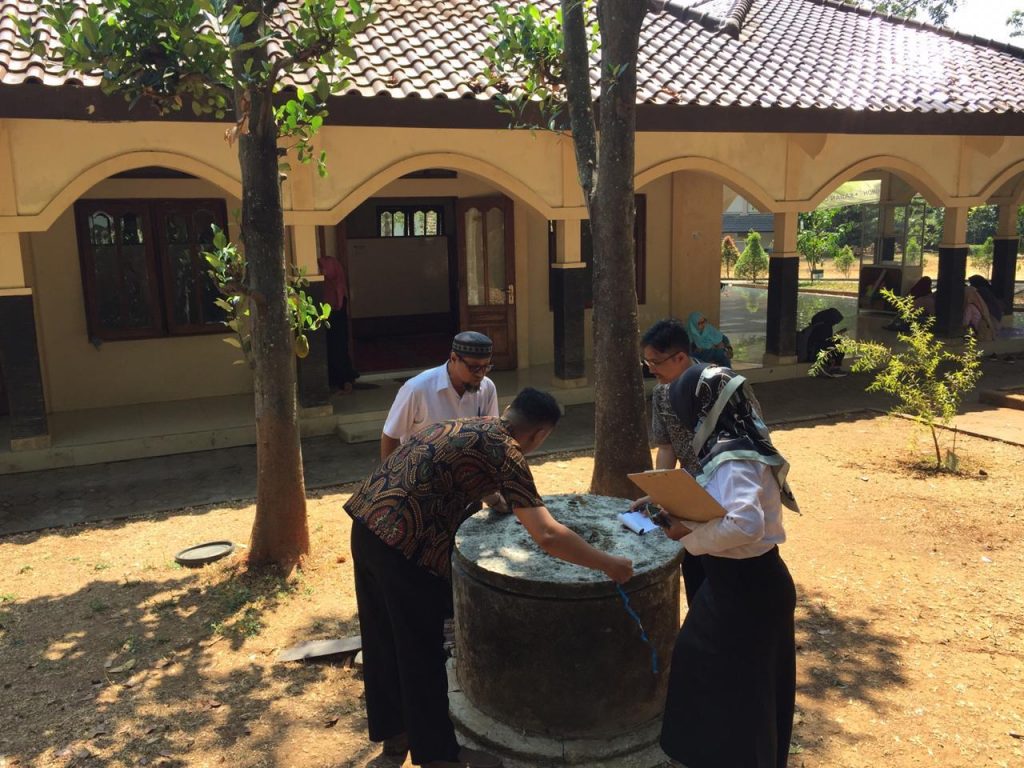
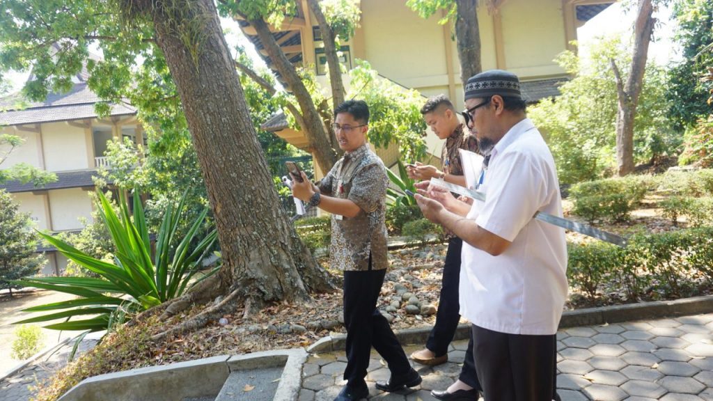
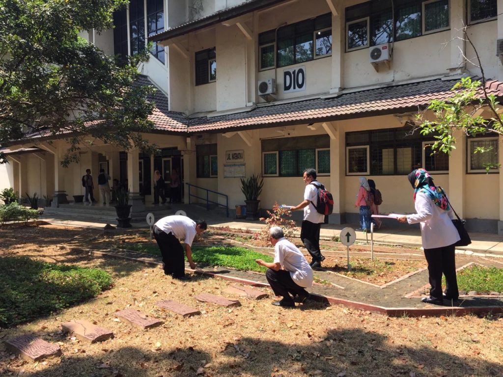
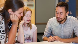
Eighteen Mathematics Teachers at the Junior High School level in the city of Semarang have participated in MathCityMap training organized by the Department of Mathematics at the Semarang State University and Universitas Negeri Semarang (UNNES) in collaboration with IDMI Goethe Universität Frankfurt Germany. The training began on September 4, 2019 and was held at the Mathematics Laboratory of UNNES and the environment around the UNNES campus.
In this 32-hour training, trainees received an explanation of MathCityMap, the theory of developing mobile math trails followed by outdoor practice around campus to try out existing math trails and also create new math trail tasks and routes. Each participant is also required to create at least one math trail route in city park near the school where they work.
This program aims to disseminate the results of research in the field of mathematics education by universities so that it benefits the community, especially schools. In addition, this program is also an effort to support the SmartCity program launched by the Semarang City Government.
At present, in Semarang City several MathCityMap trails are available, such as those available at the Tugu Muda Area, Simpang Lima Shopping Center, Indonesia Kaya City Park, the Old City, the Central Java Grand Mosque Area, and several other locations. Mathtrails with MathCityMap are also available at Taman Pintar Jogjakarta, Kota Padang Sumatera, Kota Palu Sulawesi, Telaga Tujuh Island Aceh, and several other cities.
Research on MathCityMap in Indonesia has been conducted by the Working group MATIS I from IDMI Goethe University Frankfurt Germany in collaboration with the Mathematics Department of Universitas Negeri Semarang (UNNES) since 2014. Apart from research results, MathCityMap is implemented in several regions in Indonesia both for mathematics learning activities formally in schools and for informal activities in a relaxed atmosphere. MathCityMap Trails are created in the school environment as well as in city parks, historic places, and also in tourist attractions.
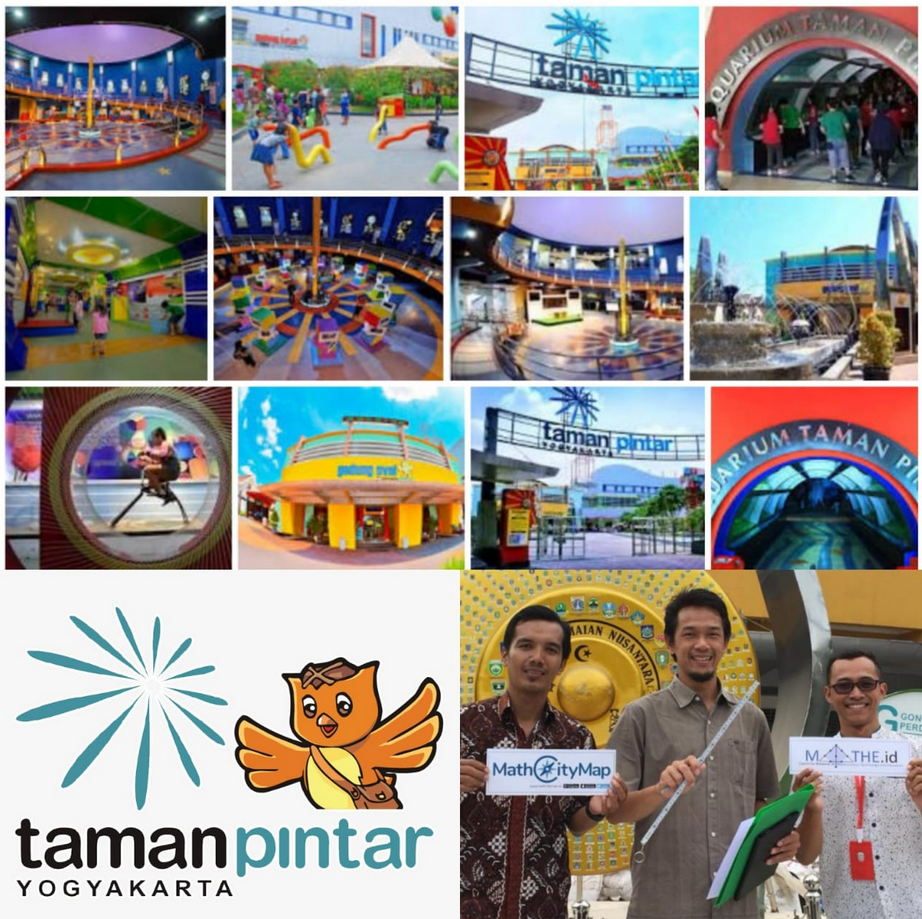
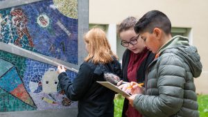
The Research Team (Dr. Puguh W Prasetyo, Afit Istiandaru, and Faris Setyawan) from Universitas Ahmad Dahlan (UAD) collaborated with a MathCityMap Educator, Dr. Adi Nur Cahyono from Universitas Negeri Semarang (UNNES), to develop the MathCityMap Trails in Taman Pintar (Smart Park), a popular education and recreation park located in the center of the Yogyakarta City.
This program is part of the Digital Sciences Tourism development program funded by the City Government of Yogyakarta in 2019. The research team coordinates with Taman Pintar managers to discuss the math trails that are designed as one of the platforms in the park as well as activities to be carried out by utilizing trails which has been made. There are 3 levels of trails that can be chosen, namely the elementary, middle and high school levels which contain mathematical problems related to the educational objects in this park.
Visitors can explore mathematics in this park by using the MathCityMap App with friends or family to play and learn mathematics and get to know educative objects in a pleasant atmosphere. This program combines recreational and educational activities and emphasizes the concept of popularization of mathematics. This year, the manager of Taman Pintar also plans to use these MathCityMap Trails in organizing math and science competitions that have been routinely held every year.
After being tested, MathCityMap in Taman Pintar will be officially launched and socialized by inviting schools in the Yogyakarta City Government area. Taman Pintar is located in the center of Yogyakarta City and is one of the most popular tourist attractions in the city located in one of the special areas in Indonesia, the Special Region of Yogyakarta. In this special area there is also a Kingdom that is part of the Territory of Indonesia, namely the Sultanate of Yogyakarta.
Let’s visit Indonesia, let’s take a math tour at Taman Pintar Jogjakarta with MathCityMap.
As part of the joint meeting of GDM and DMV in Paderborn from 05.03. – 09.03.2018, MathCityMap was presented in various ways. First of all, on 06.03. Matthias Ludwig spoke on the Erasmus + project MoMaTrE (Mobile Math Trails in Europe), in which the cooperation partners and goals were presented on an international level. On 08.03., Iwan Gurjanow presented his research results in the field of motivation and gamification (points and leaderboard) while running a math trail. In addition, Joerg Zender considered the Math Trail idea from the point of view of performance, which led to interesting discussions on 09.03.
A special highlight for the entire team is the prize which Daniel Birnbaum and Matthias Ludwig won at the poster session. On the poster, the future-oriented technology Augmented Reality was presented, as well as first ideas to use it in school and MCM.
During the entire conference, the participants had the opportunity to test a trail in the city center of Paderborn. Of course, we took the chance and ran the trail from the perspective of the task solver with lots of fun and ambition.
At this point, we want to thank Max Hoffmann and the students of the Pelizaeus-Gymnasium for creating the tasks! Likewise, we would like to thank all interested in the project for the exciting questions and discussions.
MathCityMap was used as part of a cooperation project of the University of Paderborn under the management of Max Hoffmann with the Pelizaeus Gymnasium in Paderborn. 9th grade students created a mathematical city tour with MathCityMap. Here, you can find further information.
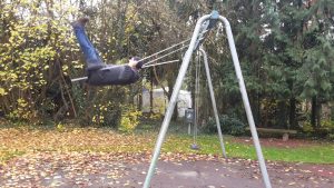
On 01.12.2017, Matthias Ludwig and Simone Jablonski presented MathCityMap as part of an internal teacher training at the Commercial Schools in Hanau. First, the theoretical basis for math trails, the MCM concept and selected research results were presented. Afterwards, the participants got to know the app with the aid of a trail created around the schoolyard – consisting of a variety of geometrical, functional and combinatorial problems. Using the criteria for good MCM tasks, the participants then became active themselves after a change in perspective and sighted the schoolyard for possible tasks. In the process, a variety of ideas for MCM on the level of secondary school appeared. As an end product of the events, the participants could create their own tasks in the portal and combine them into a trail around the school. Of course, there was a lot of fun during the event, for example while answering the question of the height of the swing seat in a 45° angle:
MCM flying high
We thank the participants for their cooperation and feedback and look forward to numerous MCM tasks in Hanau.
Are you also interested in a MCM teacher training? Feel free to contact us!
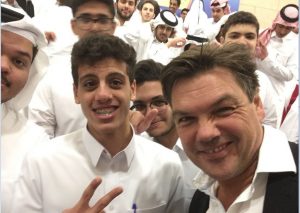
Following an invitation from the Arab-German Young Academy of Sciences and Humanities (AGYA, funded by the BMBF), Matthias Ludwig was able to introduce MCM in Doha, Qatar. First, the MathCityMap project was presented at the International German School as well as at the Omar Bin AlKhattab Boys Secondary School. This was very successful and the participants liked the MCM idea.
At the international German school
Matthias Ludwig at the Omar Bin AlKhattab Boys Secondary School
Afterwards, Matthias Ludwig had the opportunity to talk about the latest developments of MCM in the context of a podium discussion at the Texas A & M University at Qatar, where Prof. Dr. Martin Grötschl (President of the BBAW) and Mehdi BenChaabane (Qatar Foundation, Education Department) attended as well.
The vice president of the agya, Prof. Dr. Ahmad El-Guindy, was very impressed by MCM and created tasks for a Math Trail around the Khalifa International Stadium in the west of Doha with Prof. Ludwig the next day. We feel that MCM was not the last time well received in the Arab world.
Prof. Dr. Matthias Ludwig and Prof. Dr. Ahmad El-Guindy
In the ongoing development and optimization of MathCityMap, the direct impressions and experiences of students and teachers with the project provide important feedback. Accordingly, the MCM team is very interested in a lively exchange and testing of tasks.
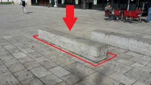
On Wednesday, 08.11.2017, the MCM team welcomed Mrs. Nazanin Roushanaei, a teacher at the Hessen-Homburg school center in Hanau, with her graduating class R10a at the Campus Westend. The students in the class will attend the Final Examinations for the secondary school certificate next spring and are currently reviewing relevant topics in math lessons, e.g. the subject of body calculations, which was compiled for the students in a diverse trail. In this context, Mrs. Roushanaei sees not only the chance to repeat exam relevant knowledge: “MCM offers the pupils the opportunity to get to know body computations in real places and in authentic situations.”
For example, the volume and weight of cuboids were discussed through benches in front of the lecture hall center. In addition to various geometric bodies, slopes and angles were calculated as well. To do this, the students had to model the selected objects with the help of familiar bodies and through flexible use of the acquired knowledge of formulas. Before the trip could start, necessary preparations were made. Due to the high number of Android devices in the class, the participants were able to agree on gamification elements, a tool that makes it possible to compete against each other and compare the results. At the moment, this tool is also planned for the iOS version. The app as well as the trail were downloaded from the class in advance, so that the actual run of the trail does not require internet connection. With the necessary materials (smartphone, pen, calculator and formulary) and the consent of the parents the trip could start.
Nazanin Roushanaei with the MCM App
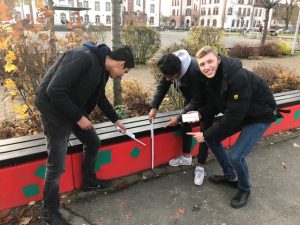
On the day of the trip, the group was confronted with rainy weather, which however could not dampen the mood. The students were divided into groups of three. This group size has been proven as there are three main functions when running a trail: navigate, measure, and record. In particular, Mrs. Roushanaei noticed a group of three, which has made up of three boys with different migration backgrounds: “Each student from this group has been totally in his role in this trip. One of them always had an overview of the tasks and could link them directly with a mathematical formula. Another boy had a very good orientation in mind and worked as a very good navigator. The third boy was able to change the required formulas correctly. Together, the three boys were able to solve most of the tasks and thereby achieve the highest score in the competition. Since that excursion, I’ve noticed that these three guys are much more motivated in math class than they used to be. I have the impression that the use of MCM and this trail could arouse the interest of these guys in mathematics.” In particular, the used gamification elements motivated the students to solve as many tasks as possible.
Measuring in the group
The feedback given by the students was very positive as well. One student with below-average mathematics performance stated: “This was the most enjoyable trip I’ve ever done with school.” Others said that through solving the tasks, they finally relate to the subject and understand what these formulas are all about. “It was fun for them. They would have liked to stay longer to solve all the tasks” says Mrs. Roushanaei.
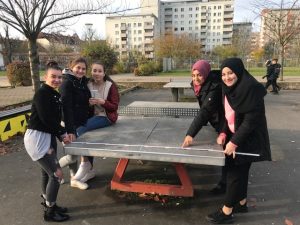
Calculations at the ping-pong table
In conclusion, Mrs. Roushanaei states: “MCM is great, not just for kids, but also for teachers. It offers the opportunity to experience mathematics outside and thereby make various calculations real. Although it is said that new textbooks have many authentic tasks; what is more authentic than having children measure real objects themselves? I can recommend any math teacher to use MCM for their own lessons and to make a project day or day trip for the class. I am convinced that, thanks to MCM, mathematics can be interesting for students even in tenth grade.”
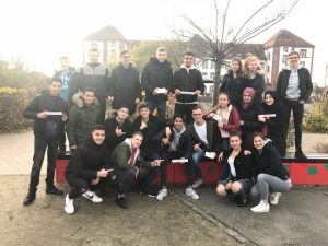
Group photo of the class
The MCM team is pleased to receive the helpful and positive feedback from the class and wishes them all the best for their further exam preparation and participation. At least in the topic of geometric bodies, nothing can go wrong now!
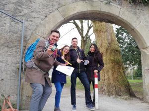
On 12.10.2017, the MathTrails project seminar from the Theodosius-Florentini-Schule Gemünden visited the MathCityMap team in Frankfurt. Marie-Noelle Klug, a participating student in the project, has thankfully provided us a great report as well as photos, which give an insight into how the students have experienced the day:
The P-Seminar “MathTrails” led the students of the Q11 of the Theodosius-Florentini-Schule Gemünden to Frankfurt to get to know the origin of the project MathCityMap and to get the necessary information about the seminar.
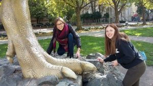
We arrived at the Goethe University in Frankfurt around 10:30 am, where we were welcomed by Iwan Gurjanow and Joerg Zender. Afterwards we were introduced to the concept of MathCityMap in detail and we got useful tips for dealing with the materials we needed to test a trail. Then we started in groups of three with our smartphones, on which we had previously installed the app MathCityMap, and made a small trail with different tasks. For example, we had to calculate the shoe size of the T Rex statue. We had a stick, measuring tape and a pocket calculator. Now one had to become creative and come to own solutions, whereby the app also provides up to three hints.
After all the groups finished the trail, we got together again and held a brief feedback round. Afterwards, we received the criteria and tips for the creation of our own tasks for a trail, what we could then test again in our small groups.
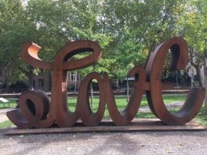
For example, the task was to “calculate the inner surface of the O”
Several tasks were created in each group, which allowed us to create the first own trail of our group on the web portal.
In conclusion, the excursion was a great success for the students and many questions were answered. The class is now very well prepared for the project and hopes for a successful end result.
In regards to the Hamburger Stiftungstage 2017, numerous MCM tasks were created on demand of the Stiftung Rechnen in the district Wilhelmsburg and combined into varied trails for families and school classes of grades 3 to 9. As part of the opening of the trails, the tasks were tested by Hamburg’s pupils as well as press representatives, and Iwan Gurjanow was able to present the MCM concept to the participants on site.
(c) Stiftung Rechnen
On the next picture you can see a group of students, which solves the task School Cone.
(c) Stiftung Rechnen
The resonance in the press, e.g. in the Hamburger Abendblatt as well as in the regional editions of the Bild und SAT 1, is consistently positive and makes clear: MCM convinces teachers and students through authentic tasks, the use of modern media and the practicability of “outdoor mathematics”.
We are thankful for the very positive feedback and hope that fun and curiosity on MCM will be awakened by many users through the continuation of the trails .
The MathCityMap idea lives from its active users and task creators in different places. Today, we would like to present a new trail at the University of Heidelberg that Mr. Niccolò Rigi-Luperti created there. In a short interview, for which he was thankfully available, we would like to let him speak for himself and give us an insight into the background to the trail creation.
How did you hear about MathCityMap?
Through my job as a scientific assistant in the project “MINTmachen!”. There, we bring students closer to MINT subjects through e.g. holiday courses, workshops at the Girls-Day or possible BOGY-stays at the university (www.mintmachen.de). My boss (Dr. Michael Winckler) had learned from MathCityMap and asked me to get to know the app to see if and how we could integrate it into our work.
How did you get the idea to create your own trail? Have you created this for a particular event or target group?
It seemed to me the best way to get a feeling for the app and the job. According the target group, I was thinking of math-physics-computer science first semesters, which should solve small group tasks in the introductory days for mutual learning. In my opinion, this is a very good way to do this, especially because they are doing maths together and seeing different campus locations.
What mathematical content and skills are required in your trail?
In the order of the four tasks: simple probability calculation, precise counting of objects, trigonometry and potential & kinetic energy, combinatorics.
Which of the tasks is your “favorite task” and why?
The third task, “wheelchair“. I think it is nice to see the slope as a large acceleration ramp. It is the only physical task, and it can be solved in different ways, but they are of varying complexity. The easiest way to do this is to use energy conservation. Doing so, you solve the problem quite efficiently, it is only necessary to do a few line transformations as well as a single length measurement.