
We all know them: city and site maps, illustrations and drawings that depict a real object to scale. Especially at sights, they offer the chance to calculate this scale, as in our Task of the Week at the Krämerbrücke in Erfurt.
Task: Scale of the Krämerbrücke (Task number: 3108)
Determine the scale 1: x in which the Krämerbrücke is drawn (engraved) on this steel plate. Give the number x.
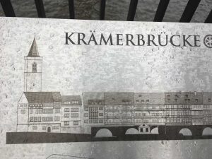
First, it has to be clarified how the scale is defined: One unit of length corresponds to x units of length in reality. In this example, the real length of the Krämerbrücke is indicated on the plate, so it is only necessary to measure their length on the plate and to compare the two values. Of course, the task can also be formulated on objects where the actual size or length has to be measured.
By the way: Do you already know the new metadata function “About this object”? This allows you to enter interesting sidefacts about sights and objects, so that cultural-historical references can be realized.
