Portal Update: Synchronization between map and list

The October update includes some changes to the web portal. An essential point is the synchronization of list and map view. What does that mean? Previously, the tasks and trails that were visible on the map were not necessarily part of the list. As a result, the list displayed content from different places and possibly […]

The October update includes some changes to the web portal. An essential point is the synchronization of list and map view. What does that mean? Previously, the tasks and trails that were visible on the map were not necessarily part of the list. As a result, the list displayed content from different places and possibly different languages.

With the new update, the currently visible map section is linked to the list. Accordingly, only tasks and trails can be seen in the list that can also be found in the current map section. This has the advantage of obtaining relevant data for your location. In addition, much less data must be loaded, which increases the speed of the web portal.

If you want to get an overview of all your tasks, a button (globe icon) on the right edge of the map will help. This zooms on the whole world and thus represents all your content.


Overview of further changes:

  • New 3D map: The MCM web portal now uses new map technology. This allows you to tilt the map (hold right mouse button and move mouse) and show or hide 3D buildings. The following actions can be performed via the control bar on the right side of the map (from top to bottom):
    • Zoom map (Zoom in)
    • Zoom map (Zoom out)
    • Align to the north
    • Show and center your own position
    • Show entire world map (zoom out to maximum)
    • Show or hide 3D buildings
    • Change map style (Street, Outdoors, Satellite)
    • Loading Indicator (indicates whether data is being reloaded)
  • Revised trail and task preview: Content does not open directly on the first click. Instead, a content preview based on the MCM app opens first.
  • Create or edit a trail: If you open the details of a trail, the list and all other trail pins will be hidden. When switching to edit mode (or when creating a new trail), tasks (Own and Public) in the current map are added to the map, which can then be assigned to the trail. In addition, these tasks also appear in the list. This makes it possible to create a trail using the list. The various sorting options can help keep track of a large amount of tasks.
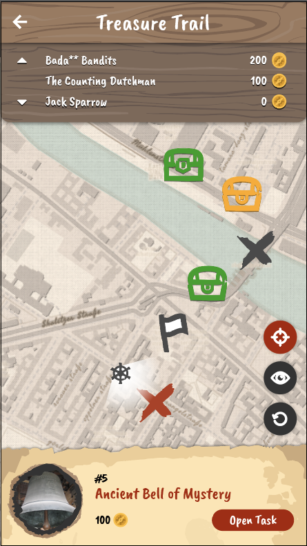
  • Customization of task and trail pins: The MCM web portal now uses the same pins as the MCM app. Tasks are represented by rounded pins. Trails are represented by square pins. In addition, there is a color and a symbolic distinction:
    • Dark Blue: Own content (created by logged in users)
    • Blue: Foreign (public) content (created and shared by another user)
    • Light Blue: Selected content (eg pin-click to preview or if details are open)
    • Circle icon (currently only trails): Public Trail
    • Key Icon (currently only trails): Private Trail
    • light blue (transparent): Occurs when working on a task and represents the previous task item.
    • Note: The colors will be adjusted and optimized in the near future.
  • New Tasks Wizard – Age of the tree: The task wizard has been extended by another template. The task deals with the calculation of the age of a tree from measured circumference (in cm) and given growth factor of the diameter (in cm per year). At present, there is a wide choice of trees in Europe, such as maple, birch, beech, oak, etc. This task can be found under the category “growth”.
  • Sessions: Running paths are no longer collectively displayed on the map. Instead, each user will see their own track based on their events as soon as they click on the user (list or map). In addition, the events are marked as small circles on the map and can be clicked for more information. It is now possible to retrieve the path of a user later.
  • Review: The review process has been partially changed and adapted:
    • Logged in users can view the review history for their own tasks and trails.
    • If a trail was rejected and a user tries to re-submit it directly, an error message appears. The error message says that first the feedback of all rejected tasks of the trail must be read and confirmed before a re-submission is possible.
    • Reviewers must now leave a message to complete a review.
    • A trail can only be published if none of the tasks have recently been rejected.
    • Reviewers will now receive a quick feedback as soon as they have made a decision.
    • If a trail is submitted for publication, a reviewer can now see all the tasks of the trail, even if they do not need to be reviewed. In terms of color, these are coded as follows:
      Light blue opaque: Task Waiting for Review
      Light blue transparent: Task has already been published
      Red: Task has already been rejected
  • Other changes:
    • Trails can now be sorted by downloads
    • New trails are highlighted in the list with a green star
    • GPS tasks now use a small red circle instead of large pins to mark positions. In addition, hints were added on how to set markers or coordinate system.
    • Extract position from images: If you upload an image for a task and it contains position data, a message appears asking if the user wants to use the image position to set the location of the task.
    • If the portal is called with an extended URL that points to a content, the user can choose to jump to that content or start the portal as usual.
    • Many alerts have now been replaced with more user-friendly custom alerts.
    • Bugfixes when creating sessions: If a session exceeds the permitted duration of 48h, an error message appears, which prevents the creation of the session. Furthermore, an automatic task assignment error was corrected in Custom mode, where the task titles were not displayed.
    • Fixed an error when changing the share for a group.
    • Updating frameworks (AngularJS, FontAwesome)
    • Small bug fixes and style adjustments

Portal & App Update: Narratives

Ahoy mateys! A new exciting feature for MathCityMap is now available both in the App and Web portal – Narratives. Narratives carry the app users away to new thematic settings. The route creators can optionally enable a specific narrative for each of their routes, the narrative gets automatically applied and can be experienced after downloading […]

Ahoy mateys! A new exciting feature for MathCityMap is now available both in the App and Web portal – Narratives. Narratives carry the app users away to new thematic settings. The route creators can optionally enable a specific narrative for each of their routes, the narrative gets automatically applied and can be experienced after downloading the route in the App.

The App’s text (such as task descriptions, hints, answer feedback, etc.), is replaced or expanded with dialogue lines from the narrative assistant: a companion that travels alongside the player and aids in their quest. The App’s graphical elements (banners, backgrounds, the map, etc.) are replaced with elements allusive to the narrative.

Our first narrative: Pirates!

And so, we present the first narrative: Pirates!

In this narrative the player is a pirate Captain that seeks to collect as many coins as possible and find the trail’s treasure! They are accompanied by their trusty parrot, Perry. Perry will help them solve riddles, getting them closer to the treasure one enigma at a time. When all the riddles are solved, the Captain finds the treasure!

To enable a narrative on a route, go to: Portal > Routes > My Routes and select the route. Then, on the route’s details click “Edit”, scroll down to the “2. Settings” tab and select the desired narrative from the dropdown list. After this, you just have to click “save” and the narrative will be applied. From that point on, when users download your route, they will have a new adventure awaiting for them.

New Graphics

The trail is now represented by a treasure map

Companion

Perry the parrot accompanies the player on his adventures.

Enabling narratives

In the section “2. Settings” select a narrative from the dropdown menu.

Our objective is to provide the MathCityMap App users with fun experiences that feel distinct, fresh, but still follow the general flow of the original math trail solving experience. As such, narrative routes will immerse the users in a small story and improve their motivation to continue solving the tasks and try even more routes.

Other changes

  • Introducing LaTex to MCM (App & Web): Writing mathematical formulas with the computer is not always easy. For a long time we have planned to support LaTex formulas in MCM. Finally, this feature is available to all users through the integration of the MathJax library. Find a documentation here.
  • Click images to enlarge (App): Images such as the title image, hint images or sample solution images can now be viewed and zoomed in a separate view, just click them.
  • Minor bug fixes.

User Survey 2019

Update 09.09.2019: The questionnaire of our user survey will be open until Sunday. We appreciate your feedback on MathCityMap to improve the system. Our web portal and the app went through major changes during the last year. Technically, we implemented new features, the layout changed, the community has been grown and so did the number […]

Update 09.09.2019: The questionnaire of our user survey will be open until Sunday. We appreciate your feedback on MathCityMap to improve the system.

Our web portal and the app went through major changes during the last year. Technically, we implemented new features, the layout changed, the community has been grown and so did the number of tasks and trails. Thanks to you as active members of the MCM community, there are MCM tasks in more than 40 countries! Moreover, we are interested in how you work with the system and what your experiences are. Therefore, we created a little online survey and kindly ask you to participate. 

Link to online survey

We appreciate your feedback on MathCityMap to improve the system.


Best wishes
The MCM-Team

Maintance notice for Thursday, 21st February

We are planning to deliver a new update this Thursday morning. Since data structure changes are involved, technical malfunctions cannot be excluded during this day. If you have disabled automatic updates for your apps, please check manually for available updates on this day on the app stores (App Store for iOS, Google Play for Android). […]

We are planning to deliver a new update this Thursday morning. Since data structure changes are involved, technical malfunctions cannot be excluded during this day.

If you have disabled automatic updates for your apps, please check manually for available updates on this day on the app stores (App Store for iOS, Google Play for Android). We advice against using an outdated version of the MCM app, since technical malfunctions could occur.

Catania between myths, legends, polygons and polyhedra: MathCityMap wins Catania over!

November 15th, 2018 a teacher training course named “MathCityMap: using and creating tasks around the city” started. It is promoted by the Accademia dei Lincei and the Department of Mathematics and Computer Science, University of Catania. As a first activity, a group of school teachers tested the first trail created in Catania. The teachers got […]

November 15th, 2018 a teacher training course named “MathCityMap: using and creating tasks around the city” started. It is promoted by the Accademia dei Lincei and the Department of Mathematics and Computer Science, University of Catania. As a first activity, a group of school teachers tested the first trail created in Catania. The teachers got in touch with the potential of the MathCityMap app and lived the city of Catania with different eyes! In fact, they met some mathematical activities, located between Villa Bellini and Piazza Duomo. Here is what they said at the end of the meeting: “it was fun, engaging and interesting. It could be an excellent dissemination tool, and from an educational point of view it is an excellent opportunity to involve students by letting them doing mathematics in an interdisciplinary, contextualised, real and concrete educational context”

Impressions


Authors: Angelo Ariosto, Daniela Ferrarello, Eugenia Taranto.

MoMaTrE workshops in Nitra

MoMaTrE (Mobile Math Trails in Europe) – this is the name of the european project to spread technology supported math trails in Portugal, Spain, France, Germany and Slovakia. From 6th until 9th of November Moritz Baumann and Iwan Gurjanow (both Goethe University) visited Nitra (Slovakia) and carried out several workshops in collaboration with Sona Ceretkova (Professor for mathematics education […]

MoMaTrE (Mobile Math Trails in Europe) – this is the name of the european project to spread technology supported math trails in Portugal, Spain, France, Germany and Slovakia. From 6th until 9th of November Moritz Baumann and Iwan Gurjanow (both Goethe University) visited Nitra (Slovakia) and carried out several workshops in collaboration with Sona Ceretkova (Professor for mathematics education at the university Konštantína Filozofa v Nitre) with the focus on outdoor modelling with MathCityMap.

Workshops

The workshop preparations took place on Tuesday afternoon. In this context we created a math trail that contains ten tasks, that the participants of the workshops should complete. Amongst other things, the current task of the week is part of the trail. The area around the university as well as the beautiful old town of Nitra have been inspected and suitable objects were photographed and measured.

On Wednesday and Thursday morning two sessions of 90 minutes each for teacher students took place. The future teachers could gain insights into the theory of education outside the classroom, the theory of math trails as well as mathematical modelling. However, the participants had the most fun with the practical part in which they had to complete the math trail (see series of pictures).  During the math trail, the new digital classroom feature could be successfully tested. The second session focused on creating a math trail with the use of MathCityMap. The participants showed great interest in the project and participated actively in the work phases. For us, the practical phases of a workshop are very important. They allow future teachers to get in touch with the new technology and to reduce fears to use digital media in classroom. Hopefully, this contributes to an increased use of digital media and in this context of MathCityMap in the real mathematics classroom in the future.

On Wednesday afternoon, teacher students of the primary school listened to a lecture about math trails and modelling. The lecture was held in English and translated simultaniously into Slovakish (see impressions in the lecture hall). It was the first time that students were able to attend an international lecture and certainly aroused interest, for example in participating in the Intensive Program for Mathtrails at the Goethe University in March 2019. The exchange between students and lecturers from the participating European countries is one of the goals of the Erasmus + project.

The travel was concluded by a 3 hours workshop for in-service teachers of mathematics in Nitra. The session was structured in a similiar way as described above and offered the participants to get in touch with new possibilities of integrating smartphones in their mathematics classroom.

Conclusion

Overall, we consider the meeting in Nitra a great success for the European project. The events was tightly clocked and could all be successfully completed. The cooperation and the exchange with the Slovak lecturers was furthermore informative for us. We were able to enjoy a great hospitality, get to know the beautiful city in the short spare time in an authentic way and learn about the Slovak education system. The next MoMaTrE project meeting will take place in Nitra too and we look forward to it!

Impressions

The following pictures show impressions of the city and our workshops.

Portal update: Create task drafts on the fly!

Today’s update extends the web portal with an important new feature. The mobile version of the portal (e.g. on mobile devices) now automatically starts in the so-called “draft mode”. It is a reduced and light weight view that displays the map and a plus button at the bottom right hand corner. Clicking this button allows […]

Patch Notes

Today’s update extends the web portal with an important new feature. The mobile version of the portal (e.g. on mobile devices) now automatically starts in the so-called “draft mode”. It is a reduced and light weight view that displays the map and a plus button at the bottom right hand corner. Clicking this button allows to quickly create a task draft. Just add a picture via your smartphone and click on the “Get position” button to automatically set your position. The task draft will be accessible in the “My tasks” area. This features allows users to quickly create a task draft while they are outside that can be polished and finished later on at home. There is still the possibility to use all web portal functionalities on your mobile as well – just switch to “Default mode”. For more information take a look at the attached tutorial video.


Further changes:

  • Added caching of tasks: Freshly created task will be cached. If a user closes the new task form by mistake, the task creation can be continued by clicking on “New task” > “Draft”. This behaviour should prevent data loss.
  • Added possibility to remove task images: Title images and sample solution images may now be marked for deletion by clicking on the “Trash”-icon of the according image while editing a task. When the user saves the made changes, the marked images will be deleted (see image 4).
  • Moved mathematical symbols to the quick-jump bar: One can now toggle the mathematical symbols table via the “Omega”-sign inside the quick-jump bar next to the details window. (see image 3)
  • Preparation for the ‘digital classroom’ and sub tasks: Made many backend changes and adjustment to prepare the web portal for the introduction of the ‘digital classroom’ and sub tasks that will be activated this year.
  • Other changes:
    • Items that were shared by a group will be highlighted with the group name they come from inside the list view.
    • Removed gamification option ‘Leaderboard’ from trails menu. This option will be available again in the ‘digital classroom’ feature.
    • Fixed problems with decimal numbers in the task wizard in Internet Explorer and Firefox.
    • Small bugfixes and style changes.


How do you like MathCityMap?

Your opinion is important to us! We are always looking forward to hear about your opinion on the MathCityMap project. Your experiences and suggestions are important to improve our further development! Please fill out the following form to tell us about your experiences with the MCM project: https://docs.google.com/forms/d/1IoYWMFxqDhgXIjpU-_q0PsJ21dDogU8y7y8zOKFlni0

Your opinion is important to us!

We are always looking forward to hear about your opinion on the MathCityMap project. Your experiences and suggestions are important to improve our further development!

Please fill out the following form to tell us about your experiences with the MCM project:

https://docs.google.com/forms/d/1IoYWMFxqDhgXIjpU-_q0PsJ21dDogU8y7y8zOKFlni0

New homepage online!

The new homepage is finally online. On top is a welcome-slider located. This one explains the project MathCityMap in a few titled pictures and enables first insights. The quick start area is located directly underneath. Here are all the important functions of MCM linked together: The MCM portal: Registered users can create and edit tasks and […]

The new homepage is finally online. On top is a welcome-slider located. This one explains the project MathCityMap in a few titled pictures and enables first insights. The quick start area is located directly underneath. Here are all the important functions of MCM linked together:

  • The MCM portal: Registered users can create and edit tasks and routes. These can be used with help of the MCM app.
  • Tutorials: This page will provide you soon with handling and instructions of MathCityMap.
  • Publication: This page will provide you soon with scientific publications about Math Trails and MCM.
  • News: Click on news and you will get to the lower part of the homepage, a list of current contributions will be displayed.

Links to recent contributions and categories as well as project description can be found at the sidebar located on the right, next to the homepage.

Outlook:

During the next few days and weeks we will start to publish tutorials and publications. At the same time we work on an English version of MathCityMap for the ICME13 conference in Hamburg. Furthermore there will be a covarage on different math trails. It is also possible to comment news and math trails.